IMAGES TAKEN NEAR TO
College Gardens, BRIGHTON, BN2 1HP
Introduction
This page details the photographs taken nearby to College Gardens, BN2 1HP by members of the Geograph project.
The Geograph project started in 2005 with the aim of publishing, organising and preserving representative images for every square kilometre of Great Britain, Ireland and the Isle of Man.

There are currently over 7.5m images from over14,400 individuals and you can help contribute to the project by visiting https://www.geograph.org.uk
Image Map
Images are licensed for reuse under creativecommons.org/licenses/by-sa/2.0
Notes
- Clicking on the map will re-center to the selected point.
- The higher the marker number, the further away the image location is from the centre of the postcode.
Image Listing (470 Images Found)
Images are licensed for reuse under creativecommons.org/licenses/by-sa/2.0
Image
Details
Distance
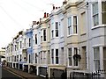
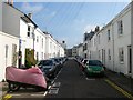
2
College Gardens, Kemp Town, Brighton
A cul de sac off College Place developed in the early 1850s.
Image: © Simon Carey
Taken: 4 Oct 2015
0.01 miles
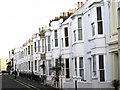
3
Bloomsbury Street
Small side street linking College Place with St George's Road developed in the late 1830s.
Image: © Simon Carey
Taken: 11 Jan 2009
0.02 miles
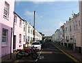
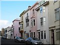
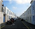
5
Bloomsbury Street, Kemp Town, Brighton
A residential road that links College Place to St George's Road that was developed in the late 1830s.
Image: © Simon Carey
Taken: 4 Oct 2015
0.02 miles
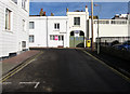
7
College Place, BN2 (2)
North of St. George's Road.
Image: © Mike Quinn
Taken: 24 Apr 2012
0.04 miles
8
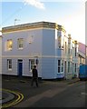
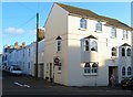
30, College Place, Kemp Town, Brighton
Located on the southern corner of Great College Street the building began life as a public house in the 1850s, initially Lewes Arms then the College Arms but had closed by 1862. It then became a grocer and during much of the 20th century it was Munnery's off licence. Now a private dwelling.
Image: © Simon Carey
Taken: 13 Nov 2015
0.04 miles
9
42, College Place, Kemp Town, Brighton
The current set of flats look like a rebuild or redevelopment but occupy the site of what was once the Dolphin Tavern which operated here from the 1850s until its closure around 1909. Located on the corner of Bloomsbury Street.
Image: © Simon Carey
Taken: 13 Nov 2015
0.04 miles
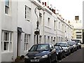
10
Great College Street, Kemp Town, Brighton
A residential road linking College Place with Abbey Road that was developed in the late 1850s. Whilst no houses in the street are listed at least three lamp posts are.
Image: © Simon Carey
Taken: 4 Oct 2015
0.04 miles