IMAGES TAKEN NEAR TO
Sussex Square, BRIGHTON, BN2 1FJ
Introduction
This page details the photographs taken nearby to Sussex Square, BN2 1FJ by members of the Geograph project.
The Geograph project started in 2005 with the aim of publishing, organising and preserving representative images for every square kilometre of Great Britain, Ireland and the Isle of Man.

There are currently over 7.5m images from over14,400 individuals and you can help contribute to the project by visiting https://www.geograph.org.uk
Image Map
Images are licensed for reuse under creativecommons.org/licenses/by-sa/2.0
Notes
- Clicking on the map will re-center to the selected point.
- The higher the marker number, the further away the image location is from the centre of the postcode.
Image Listing (279 Images Found)
Images are licensed for reuse under creativecommons.org/licenses/by-sa/2.0
Image
Details
Distance
1
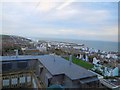
View from Sussex County Hospital
Taken from the Tower Block looking towards Brighton Marina
Image: © Paul Gillett
Taken: 5 Nov 2013
0.00 miles
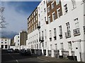
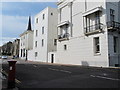
2
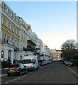
Sussex Square, Kemp Town, Brighton
A view of numbers 1-10 between Lewes Crescent and Eastern Road. Building for the square started in 1823 with the facades completed by 1827 after which individual builders would be hired to complete the interiors when they were purchased. Number 1 on the left is now used as an EF Language School.
Image: © Simon Carey
Taken: 13 Nov 2015
0.01 miles
4
Sussex Square, BN2 (west side, south of Eastern Road)
Shows the location of Image
Image: © Mike Quinn
Taken: 19 Apr 2012
0.01 miles
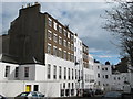
6
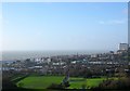
Kemp Town, Brighton
Viewed from Red Hill with the original estate to the left. The modern suburb of Kemp Town stretches from Boundary Road in the east to Bedford Street/Upper Bedford Street in the west. Thomas Kemp Tower is on the far right and is part of the Royal Sussex county Hospital complex whilst in the foreground is East Brighton Park beyond which is the southern end of Whitehawk.
Image: © Simon Carey
Taken: 31 Dec 2015
0.02 miles
7
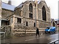
St Mark's Church, Kemp Town
Former Anglican church decommissioned in 1985 and now used as St Mary's Hall school chapel
http://en.wikipedia.org/wiki/St_Mark's_Church,_Brighton
Image: © Paul Gillett
Taken: 5 Feb 2011
0.02 miles
8
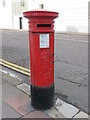
Edward VII postbox, Eastern Road / Sussex Square, BN2
Image: © Mike Quinn
Taken: 19 Apr 2012
0.02 miles
9
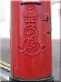
Edward VII postbox, Eastern Road / Sussex Square, BN2 - royal cipher
See Image
Image: © Mike Quinn
Taken: 19 Apr 2012
0.02 miles
10
Eastern Road, BN2 (between Sussex Square and Church Place)
Shows the location of Image
Image: © Mike Quinn
Taken: 19 Apr 2012
0.03 miles