IMAGES TAKEN NEAR TO
Marine Parade, BRIGHTON, BN2 1DD
Introduction
This page details the photographs taken nearby to Marine Parade, BN2 1DD by members of the Geograph project.
The Geograph project started in 2005 with the aim of publishing, organising and preserving representative images for every square kilometre of Great Britain, Ireland and the Isle of Man.

There are currently over 7.5m images from over14,400 individuals and you can help contribute to the project by visiting https://www.geograph.org.uk
Image Map
Images are licensed for reuse under creativecommons.org/licenses/by-sa/2.0
Notes
- Clicking on the map will re-center to the selected point.
- The higher the marker number, the further away the image location is from the centre of the postcode.
Image Listing (494 Images Found)
Images are licensed for reuse under creativecommons.org/licenses/by-sa/2.0
Image
Details
Distance
1
Marine Parade. BN2 (3)
Between Marine Square and Bloomsbury Place.
Image: © Mike Quinn
Taken: 24 Apr 2012
0.02 miles
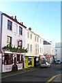
2
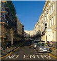
Bloomsbury Place
Small side street linking Marine parade to St George's Road and built around the 1820s.
Image: © Simon Carey
Taken: 19 Nov 2011
0.02 miles
3
Clarges, Marine Parade
Former hotel once owned by actress/Comedienne Dora Bryan. The hotel scenes from Carry On At Your Convenience were filmed here.
Image: © Simon Carey
Taken: 25 Dec 2006
0.03 miles
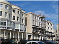
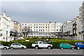
4
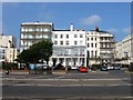
Brighton: Marine Square
Marine Square was built between 1823 and 1825 for Thomas Attree, probably to the designs of Charles Busby and Amon Wilds. All of these houses have verandahs and balconies. Marine Parade is in the foreground.
Image: © Nigel Cox
Taken: 8 Jun 2008
0.03 miles
5
109-114, Marine Parade, Brighton
Located between Crescent Place and Marine Square, with numbers 113-144 on the right architecturally part of the latter which was developed in the mid 1820s. 109-110 on the left has had a glass front added.
Image: © Simon Carey
Taken: 4 Oct 2015
0.03 miles
6
Bloomsbury Place, Kemp Town, Brighton
A residential street linking Marine Parade to St George's Road that was developed in the 1810s. Much of the street is listed and numbers 16-18 provide the terminal view with the entrance to St George's Road off to the right.
Image: © Simon Carey
Taken: 1 Nov 2015
0.03 miles
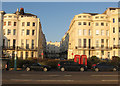
7
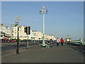
Marine Parade, Brighton
Marine Parade is the route of the coast road eastwards out of Brighton. The seafront is down below the railings on the right hand side of the image.
Image: © Malc McDonald
Taken: 10 Apr 2011
0.04 miles
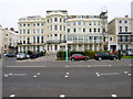
8
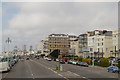
Brighton, Marine Parade
The A259, approaching Brighton sea front.
Image: © David Dixon
Taken: 5 Aug 2012
0.04 miles
9
The Barley Mow, St George's Road, Kemp Town, Brighton
Located at number 92 and opened in the 1830s.
Image: © Simon Carey
Taken: 1 Nov 2015
0.04 miles
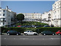
10
Marine Square - Brighton
Built 1825-1828. Architect, C A Busby or Amon Wilds and C A Busby.
Image: © David Brogan
Taken: 25 Mar 2007
0.04 miles