IMAGES TAKEN NEAR TO
St. Johns Mews, Bristol Road, BRIGHTON, BN2 1BD
Introduction
This page details the photographs taken nearby to St. Johns Mews, Bristol Road, BN2 1BD by members of the Geograph project.
The Geograph project started in 2005 with the aim of publishing, organising and preserving representative images for every square kilometre of Great Britain, Ireland and the Isle of Man.

There are currently over 7.5m images from over14,400 individuals and you can help contribute to the project by visiting https://www.geograph.org.uk
Image Map
Images are licensed for reuse under creativecommons.org/licenses/by-sa/2.0
Notes
- Clicking on the map will re-center to the selected point.
- The higher the marker number, the further away the image location is from the centre of the postcode.
Image Listing (567 Images Found)
Images are licensed for reuse under creativecommons.org/licenses/by-sa/2.0
Image
Details
Distance
1
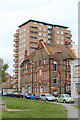
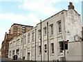
Bristol Road, Kemp Town, Brighton
The B2118 as it heads towards the junction with Bedford Street and Upper Bedford Street that was developed from the early 1860s onwards. On the right is the St Joseph's Convent of Mercy that have occupied the site since the 1850s and the current building since 1893. Beyond the convent just visible behind the tree is Image
Image: © Simon Carey
Taken: 4 Oct 2015
0.01 miles
2
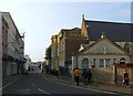
St John the Baptist Church, Bristol Road, Kemp Town, Brighton
A Catholic church that was opened in 1835 and contains the tomb of Maria Fitzherbert, 'wife' of George IV
Image: © Simon Carey
Taken: 4 Oct 2015
0.01 miles
3
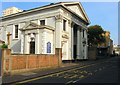
St. John The Baptist Catholic Chapel, Bristol Road, BN2
Image: © Mike Quinn
Taken: 24 Apr 2012
0.01 miles
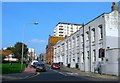
4
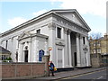
Former school, Upper Bedford Street / Upper St. James's Street, BN2
Image: © Mike Quinn
Taken: 24 Apr 2012
0.02 miles
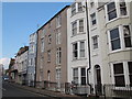
5
Fitzherbert Centre, Upper Bedford Street, Kemp Town
Originally a school belonging to neighbouring Image that lost its secondary pupils to a new school in Woodingdean in 1955 and later the rest to a new building in Whitehawk Hill Road. After that it became the Fitzherbert Centre part of which was used as a homeless shelter until 2008 when forced to close after an arson attack. Not sure what it is being used for at present though it is still owned by the church and I've seen suggestions in including it within the Marine parade/East Cliff conservation area. Beyond is Image
Upper Bedford Street runs from the B2118 northwards to Eastern Road and as a general rule of thumb is often seen as the western boundary of Kemp Town.
Image: © Simon Carey
Taken: 4 Oct 2015
0.02 miles
8
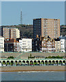
Brighton seen from the pier
This is a telephoto image looking from the southern part of the pier towards the television transmission station on the Whitehawk Hill 1900 metres away.
Image: © Roger D Kidd
Taken: 1 Jan 2013
0.03 miles
9
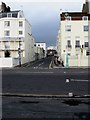
Bedford Street
Small street linking Marine Parade with Upper St James' Street. The house on the right, Bedford House, was for a number of years the home of Sir Terrence Rattigan, the playwright.
Image: © Simon Carey
Taken: 20 Feb 2009
0.03 miles