IMAGES TAKEN NEAR TO
Marine Gardens, BRIGHTON, BN2 1AH
Introduction
This page details the photographs taken nearby to Marine Gardens, BN2 1AH by members of the Geograph project.
The Geograph project started in 2005 with the aim of publishing, organising and preserving representative images for every square kilometre of Great Britain, Ireland and the Isle of Man.

There are currently over 7.5m images from over14,400 individuals and you can help contribute to the project by visiting https://www.geograph.org.uk
Image Map
Images are licensed for reuse under creativecommons.org/licenses/by-sa/2.0
Notes
- Clicking on the map will re-center to the selected point.
- The higher the marker number, the further away the image location is from the centre of the postcode.
Image Listing (616 Images Found)
Images are licensed for reuse under creativecommons.org/licenses/by-sa/2.0
Image
Details
Distance
2
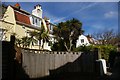
Brighton: backs of houses on Charlotte Street, from Marine Gardens
Image: © Christopher Hilton
Taken: 26 Mar 2019
0.01 miles
3
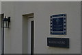
Brighton: Marine House, Marine Gardens, former home of Dame Flora Robson
Image: © Christopher Hilton
Taken: 26 Mar 2019
0.01 miles
5
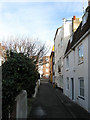
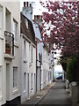
Marine Gardens
Formerly a service road for the bigger houses in Charlotte Street to the east. Beyond the first cottage in view is number 14 which was home to actress Dame Flora Robson between 1961-76, Following that is number 12 a small cobble fronted cottage of the first decade of the 19th century. The yellow building at the end is the Hand in Hand public house.
Image: © Simon Carey
Taken: 11 Jan 2009
0.02 miles
6
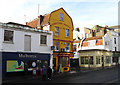
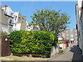
Hand in Hand, Upper St James's Street
Small pub and micro brewery in the eastern end of Kemp Town very popular with real ale buffs. The original Kemptown brewery operated from 1933, having previously been Bristol Brewery from the 1840s, until 1963 when it was taken over by Charringtons and closed by 1966. The current Kemptown Brewery dates from 1989.
Image: © Simon Carey
Taken: 11 Jan 2009
0.02 miles
7
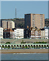
Brighton seen from the pier
This is a telephoto image looking from the southern part of the pier towards the television transmission station on the Whitehawk Hill 1900 metres away.
Image: © Roger D Kidd
Taken: 1 Jan 2013
0.02 miles
9
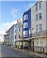
15, Bedford Street, Brighton
The blue building with scaffolding was a short-lived public house called the Stormy Petrel. It was open between 1876 and 1877. Most of the buildings in Bedford Street date back to the 1820s.
Image: © Simon Carey
Taken: 2 Jan 2025
0.03 miles
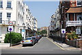
10
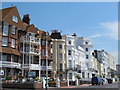
Marine Parade (A259), BN2 (9)
East of Charlotte Street.
Image: © Mike Quinn
Taken: 22 May 2012
0.03 miles