IMAGES TAKEN NEAR TO
Calverley Road, EASTBOURNE, BN21 4SR
Introduction
This page details the photographs taken nearby to Calverley Road, BN21 4SR by members of the Geograph project.
The Geograph project started in 2005 with the aim of publishing, organising and preserving representative images for every square kilometre of Great Britain, Ireland and the Isle of Man.

There are currently over 7.5m images from over14,400 individuals and you can help contribute to the project by visiting https://www.geograph.org.uk
Image Map
Images are licensed for reuse under creativecommons.org/licenses/by-sa/2.0
Notes
- Clicking on the map will re-center to the selected point.
- The higher the marker number, the further away the image location is from the centre of the postcode.
Image Listing (487 Images Found)
Images are licensed for reuse under creativecommons.org/licenses/by-sa/2.0
Image
Details
Distance

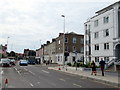
3
Hyde Road junction with Gildredge Road Eastbourne
Image: © Roy Hughes
Taken: 9 Sep 2019
0.02 miles
6
Calverley Walk
Pedestrianised shopping walk.
Image: © N Chadwick
Taken: 12 Apr 2010
0.05 miles

10
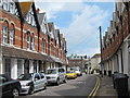
Hyde Road
Curved Victorian terrace of houses.
Image: © Oast House Archive
Taken: 23 Jun 2011
0.05 miles