IMAGES TAKEN NEAR TO
South Street, EASTBOURNE, BN21 4LD
Introduction
This page details the photographs taken nearby to South Street, BN21 4LD by members of the Geograph project.
The Geograph project started in 2005 with the aim of publishing, organising and preserving representative images for every square kilometre of Great Britain, Ireland and the Isle of Man.

There are currently over 7.5m images from over14,400 individuals and you can help contribute to the project by visiting https://www.geograph.org.uk
Image Map
Images are licensed for reuse under creativecommons.org/licenses/by-sa/2.0
Notes
- Clicking on the map will re-center to the selected point.
- The higher the marker number, the further away the image location is from the centre of the postcode.
Image Listing (525 Images Found)
Images are licensed for reuse under creativecommons.org/licenses/by-sa/2.0
Image
Details
Distance
1

Valentine Court, South Street Eastbourne
Image: © PAUL FARMER
Taken: 12 Jul 2012
0.01 miles

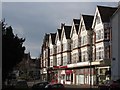
3

South Street, Eastbourne
A parade of shops on South Street, Eastbourne.
Image: © Malc McDonald
Taken: 12 Feb 2011
0.02 miles
4
Lushington Lane
Small back lane running parallel with South Street and linking Gildredge Road with Lushington Road.
Image: © Simon Carey
Taken: 3 Feb 2008
0.03 miles
5

St Saviour's Church, South Street, Eastbourne
Image: © PAUL FARMER
Taken: 12 Jul 2012
0.03 miles
6

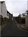
South Street
Shopping road on the outskirts of the town centre.
Image: © Oast House Archive
Taken: 5 Dec 2011
0.04 miles
8
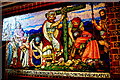
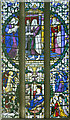
King Oswald at Heavenfield
A mosaic of 1867 by Clayton & Bell in St Saviour's Church, showing the Northumbrian king on the eve of his victory in or about AD 634 against the pagan Welsh under Cadwallon ap Cadfan. The site of the battle is near Hexham in Image
St Saviour's is listed Grade II* https://britishlistedbuildings.co.uk/101190569-church-of-st-saviour-eastbourne-meads-ward
Sussex Churches https://sussexparishchurches.org/church/eastbourne-st-saviour-south-street/
Image: © Tiger
Taken: 22 Jan 2020
0.04 miles
9
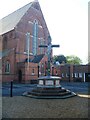
War memorial
In the grounds of the church of St Saviour and St Paul stands this war memorial commemorating 57 local men. Unveiled in 1920, the memorial comprises a wooden cross bearing a white figure of Christ crucified, set upon a red brick octagonal plinth. This stands on a three-stepped base. Listed, grade II, with details at: https://historicengland.org.uk/listing/the-list/list-entry/1441519
Eastbourne is a town and seaside resort on the south coast of East Sussex, some 54 miles south of London and about 19 miles east of Brighton. Although there is evidence of settlement from the Stone Age onwards, Eastbourne remained an area of small rural settlements until the railway arrived in 1849. A resort, built "for gentlemen by gentlemen", was planned and the town's growth accelerated from a population of less than 4,000 in 1851 to nearly 35,000 by 1891. Tourism is a large and important part of the economy of the town.
Image: © Michael Dibb
Taken: 5 May 2022
0.04 miles
10
South Street
Shopping road on the outskirts of the town centre.
Image: © Oast House Archive
Taken: 5 Dec 2011
0.04 miles