IMAGES TAKEN NEAR TO
College Road, EASTBOURNE, BN21 4HY
Introduction
This page details the photographs taken nearby to College Road, BN21 4HY by members of the Geograph project.
The Geograph project started in 2005 with the aim of publishing, organising and preserving representative images for every square kilometre of Great Britain, Ireland and the Isle of Man.

There are currently over 7.5m images from over14,400 individuals and you can help contribute to the project by visiting https://www.geograph.org.uk
Image Map
Images are licensed for reuse under creativecommons.org/licenses/by-sa/2.0
Notes
- Clicking on the map will re-center to the selected point.
- The higher the marker number, the further away the image location is from the centre of the postcode.
Image Listing (483 Images Found)
Images are licensed for reuse under creativecommons.org/licenses/by-sa/2.0
Image
Details
Distance
2
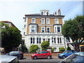
Spencer Court, Spencer Road, Eastbourne
Spencer Court was the first home of Eastbourne College, it was known then as Ellesmere Villas.
Image: © PAUL FARMER
Taken: 12 Jul 2012
0.03 miles
3
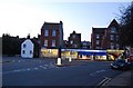
Shops on Furness Rd
The edge of Eastbourne's CBD.
Image: © N Chadwick
Taken: 12 Apr 2010
0.03 miles
4

College Court, Spencer Road, Eastbourne
Image: © PAUL FARMER
Taken: 12 Jul 2012
0.03 miles
6

Arnworth Court, Furness Road, Eastbourne
Image: © PAUL FARMER
Taken: 12 Jul 2012
0.03 miles
7
![Eastbourne houses [27]](https://s0.geograph.org.uk/geophotos/07/21/82/7218264_18e88d31_120x120.jpg)
Eastbourne houses [27]
Flint Cottage, number 4 Furness Road, is set gable end to the street and was probably built in the early 19th century. Constructed of cobbles with the gable wall rendered. Listed, grade II, with details at: https://historicengland.org.uk/listing/the-list/list-entry/1353115
Eastbourne is a town and seaside resort on the south coast of East Sussex, some 54 miles south of London and about 19 miles east of Brighton. Although there is evidence of settlement from the Stone Age onwards, Eastbourne remained an area of small rural settlements until the railway arrived in 1849. A resort, built "for gentlemen by gentlemen", was planned and the town's growth accelerated from a population of less than 4,000 in 1851 to nearly 35,000 by 1891. Tourism is a large and important part of the economy of the town.
Image: © Michael Dibb
Taken: 5 May 2022
0.03 miles
8
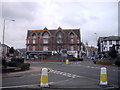
South Street
A shopping street in the district known as Little Chelsea looking towards the junction with Gildredge Road. The church in the background is St Saviours built in 1867 and in the next grid square.
Image: © Simon Carey
Taken: 19 Feb 2008
0.03 miles
9
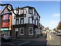
The Eagle Public House, South Street, Eastbourne
Image: © PAUL FARMER
Taken: 22 Nov 2012
0.04 miles
10

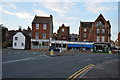
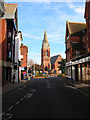
South Street
Looking towards the tower of the town hall.
Image: © Oast House Archive
Taken: 5 Dec 2011
0.04 miles