IMAGES TAKEN NEAR TO
Longstone Road, EASTBOURNE, BN21 3SJ
Introduction
This page details the photographs taken nearby to Longstone Road, BN21 3SJ by members of the Geograph project.
The Geograph project started in 2005 with the aim of publishing, organising and preserving representative images for every square kilometre of Great Britain, Ireland and the Isle of Man.

There are currently over 7.5m images from over14,400 individuals and you can help contribute to the project by visiting https://www.geograph.org.uk
Image Map (Loading...)


Getting Data...Please wait
Leaflet Map data © OpenStreetMap
Images are licensed for reuse under creativecommons.org/licenses/by-sa/2.0
Notes
- Clicking on the map will re-center to the selected point.
- The higher the marker number, the further away the image location is from the centre of the postcode.
Image Listing (153 Images Found)
Images are licensed for reuse under creativecommons.org/licenses/by-sa/2.0
Image
Details
Distance
1
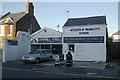
Access 4 All
Southern Mobility Centres' shop in Bourne Street, Eastbourne, which has had a varied history, including use as a slaughterhouse!
Image: © Kevin Hale
Taken: 9 Nov 2009
0.06 miles
3

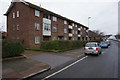
Eastbourne Blind Society
Independent local charity, committed to providing access to services, support, encouragement and information to those with visual difficulties http://www.eastbourneblindsociety.org.uk/index.htm
Image: © Paul Gillett
Taken: 3 Feb 2015
0.09 miles
4
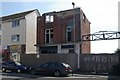
Eastbourne old fire station 4
Eastbourne old fire station 4, Cavendish Place, Eastbourne, East Sussex, now looking in a very sorry state.
Image: © Kevin Hale
Taken: 28 Jun 2010
0.09 miles
5
![Eastbourne churches [14]](https://s1.geograph.org.uk/geophotos/07/21/65/7216529_8b5d5138_120x120.jpg)
Eastbourne churches [14]
The church of All Souls in Susan's Road was built in a Byzantine style in 1882. Constructed of red brick with white brick decoration. Listed, grade II*, with details at: https://historicengland.org.uk/listing/the-list/list-entry/1353105
Eastbourne is a town and seaside resort on the south coast of East Sussex, some 54 miles south of London and about 19 miles east of Brighton. Although there is evidence of settlement from the Stone Age onwards, Eastbourne remained an area of small rural settlements until the railway arrived in 1849. A resort, built "for gentlemen by gentlemen", was planned and the town's growth accelerated from a population of less than 4,000 in 1851 to nearly 35,000 by 1891. Tourism is a large and important part of the economy of the town.
Image: © Michael Dibb
Taken: 5 May 2022
0.10 miles
6
![Eastbourne churches [15]](https://s2.geograph.org.uk/geophotos/07/21/65/7216530_68f37702_120x120.jpg)
Eastbourne churches [15]
The church of All Souls in Susan's Road was built in a Byzantine style in 1882. Constructed of red brick with white brick decoration. Listed, grade II*, with details at: https://historicengland.org.uk/listing/the-list/list-entry/1353105
Eastbourne is a town and seaside resort on the south coast of East Sussex, some 54 miles south of London and about 19 miles east of Brighton. Although there is evidence of settlement from the Stone Age onwards, Eastbourne remained an area of small rural settlements until the railway arrived in 1849. A resort, built "for gentlemen by gentlemen", was planned and the town's growth accelerated from a population of less than 4,000 in 1851 to nearly 35,000 by 1891. Tourism is a large and important part of the economy of the town.
Image: © Michael Dibb
Taken: 5 May 2022
0.10 miles
7
![Eastbourne churches [16]](https://s1.geograph.org.uk/geophotos/07/21/65/7216533_e76bf536_120x120.jpg)
Eastbourne churches [16]
The west end of the church of All Souls in Susan's Road. It was built in a Byzantine style in 1882. Constructed of red brick with white brick decoration. Listed, grade II*, with details at: https://historicengland.org.uk/listing/the-list/list-entry/1353105
Eastbourne is a town and seaside resort on the south coast of East Sussex, some 54 miles south of London and about 19 miles east of Brighton. Although there is evidence of settlement from the Stone Age onwards, Eastbourne remained an area of small rural settlements until the railway arrived in 1849. A resort, built "for gentlemen by gentlemen", was planned and the town's growth accelerated from a population of less than 4,000 in 1851 to nearly 35,000 by 1891. Tourism is a large and important part of the economy of the town.
Image: © Michael Dibb
Taken: 5 May 2022
0.10 miles
8
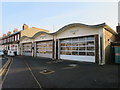
Former ambulance station, Dursley Road
The ambulance station closed in 2016 and will be demolished for new housing.
Image: © Oast House Archive
Taken: 27 Jan 2017
0.11 miles
10
![Eastbourne houses [22]](https://s0.geograph.org.uk/geophotos/07/21/65/7216536_574a875d_120x120.jpg)
Eastbourne houses [22]
The vicarage for the adjacent church of All Souls in Susan's Road was built in 1882 in a similar Byzantine style in 1882. Constructed of red brick with white and coloured brick decoration under a slate roof. Listed, grade II, with details at: https://historicengland.org.uk/listing/the-list/list-entry/1043656
Eastbourne is a town and seaside resort on the south coast of East Sussex, some 54 miles south of London and about 19 miles east of Brighton. Although there is evidence of settlement from the Stone Age onwards, Eastbourne remained an area of small rural settlements until the railway arrived in 1849. A resort, built "for gentlemen by gentlemen", was planned and the town's growth accelerated from a population of less than 4,000 in 1851 to nearly 35,000 by 1891. Tourism is a large and important part of the economy of the town.
Image: © Michael Dibb
Taken: 5 May 2022
0.11 miles