IMAGES TAKEN NEAR TO
Waterford Mews, Lismore Road, EASTBOURNE, BN21 3LF
Introduction
This page details the photographs taken nearby to Waterford Mews, Lismore Road, BN21 3LF by members of the Geograph project.
The Geograph project started in 2005 with the aim of publishing, organising and preserving representative images for every square kilometre of Great Britain, Ireland and the Isle of Man.

There are currently over 7.5m images from over14,400 individuals and you can help contribute to the project by visiting https://www.geograph.org.uk
Image Map
Images are licensed for reuse under creativecommons.org/licenses/by-sa/2.0
Notes
- Clicking on the map will re-center to the selected point.
- The higher the marker number, the further away the image location is from the centre of the postcode.
Image Listing (524 Images Found)
Images are licensed for reuse under creativecommons.org/licenses/by-sa/2.0
Image
Details
Distance
1
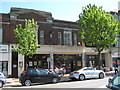
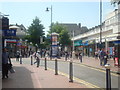
Wetherspoons, Eastbourne, Nee Cornfield Garage Ltd.
Image: © Roy Hughes
Taken: 26 Apr 2009
0.01 miles
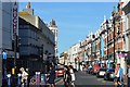
4
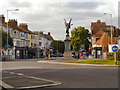
Memorial Island, Eastbourne, Looking Towards Cornfield Road.
Image: © Roy Hughes
Taken: 26 Apr 2009
0.05 miles
6
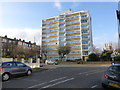
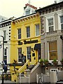
Gannet House, Hartington Place, Eastbourne
Image: © PAUL FARMER
Taken: 22 Nov 2012
0.05 miles
9
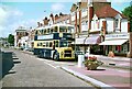
Eastbourne Corporation bus 73, Cornfield Road ? 1972
Eastbourne Corporation claims to have been the first municipality world-wide to operate motor buses, commencing in 1903. The town never had a local system of electric trams.
The bus is a Leyland PD2A with East Lancs body, built 1966, to a distinctive local specification with large top deck windows and drop-down sections for added ventilation.
This is one of a series of views featuring buses in the 60s, 70s, and 80s.
http://www.geograph.org.uk/search.php?i=2114547&displayclass=slide
Image: © Alan Murray-Rust
Taken: 5 Aug 1972
0.05 miles
10
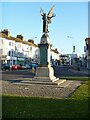
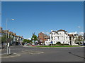
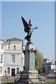
War memorial
Eastbourne war memorial stands on a roundabout at the junction of several roads. Unveiled in November, 1920, the memorial is in granite with bronze sculpture and plaques. The memorial carries no names, but over 1,000 names of the fallen are inscribed on oak panels in the Town Hall. Listed, grade II, with details at: https://historicengland.org.uk/listing/the-list/list-entry/1441521
Eastbourne is a town and seaside resort on the south coast of East Sussex, some 54 miles south of London and about 19 miles east of Brighton. Although there is evidence of settlement from the Stone Age onwards, Eastbourne remained an area of small rural settlements until the railway arrived in 1849. A resort, built "for gentlemen by gentlemen", was planned and the town's growth accelerated from a population of less than 4,000 in 1851 to nearly 35,000 by 1891. Tourism is a large and important part of the economy of the town.
Image: © Michael Dibb
Taken: 5 May 2022
0.06 miles