IMAGES TAKEN NEAR TO
Ceylon Place, EASTBOURNE, BN21 3JF
Introduction
This page details the photographs taken nearby to Ceylon Place, BN21 3JF by members of the Geograph project.
The Geograph project started in 2005 with the aim of publishing, organising and preserving representative images for every square kilometre of Great Britain, Ireland and the Isle of Man.

There are currently over 7.5m images from over14,400 individuals and you can help contribute to the project by visiting https://www.geograph.org.uk
Image Map (Loading...)


Getting Data...Please wait
Leaflet Map data © OpenStreetMap
Images are licensed for reuse under creativecommons.org/licenses/by-sa/2.0
Notes
- Clicking on the map will re-center to the selected point.
- The higher the marker number, the further away the image location is from the centre of the postcode.
Image Listing (685 Images Found)
Images are licensed for reuse under creativecommons.org/licenses/by-sa/2.0
Image
Details
Distance
1
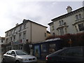
![Eastbourne churches [10]](https://s1.geograph.org.uk/geophotos/07/20/18/7201849_6e4e7962_120x120.jpg)
Eastbourne churches [10]
This elegant former Baptist Church in Ceylon Place is now flats. Built in 1871 in brick with ashlar dressings. The church was badly damaged by bombing in 1943 but reopened in 1948. The church was sold in 2005 and was converted to residential use.
Eastbourne is a town and seaside resort on the south coast of East Sussex, some 54 miles south of London and about 19 miles east of Brighton. Although there is evidence of settlement from the Stone Age onwards, Eastbourne remained an area of small rural settlements until the railway arrived in 1849. A resort, built "for gentlemen by gentlemen", was planned and the town's growth accelerated from a population of less than 4,000 in 1851 to nearly 35,000 by 1891. Tourism is a large and important part of the economy of the town.
Image: © Michael Dibb
Taken: 5 May 2022
0.01 miles
2
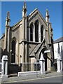
Greek Orthodox Church, Cavendish Place, Eastbourne.
Image: © Roy Hughes
Taken: 26 Apr 2009
0.03 miles
3
![Eastbourne buildings [14]](https://s2.geograph.org.uk/geophotos/07/20/02/7200242_31f26c40_120x120.jpg)
Eastbourne buildings [14]
The Royal Hippodrome theatre, numbers 106 to 114 Seaside Road, is one of the earliest Variety theatres remaining in the country. Originally named the Theatre Royal. Built in 1883 in an Italianate style with 11 bays designed to incorporate four shops and three entrances to the theatre. The box office and shops were altered in the 1930s. The construction is of brick with the symmetrical front stuccoed, all under a hipped slate roof. Listed, grade II, with details at: https://historicengland.org.uk/listing/the-list/list-entry/1246240
Eastbourne is a town and seaside resort on the south coast of East Sussex, some 54 miles south of London and about 19 miles east of Brighton. Although there is evidence of settlement from the Stone Age onwards, Eastbourne remained an area of small rural settlements until the railway arrived in 1849. A resort, built "for gentlemen by gentlemen", was planned and the town's growth accelerated from a population of less than 4,000 in 1851 to nearly 35,000 by 1891. Tourism is a large and important part of the economy of the town.
Image: © Michael Dibb
Taken: 5 May 2022
0.04 miles
5
Royal Hippodrome Theatre, Seaside Road
Built in 1883 and acquiring its name in 1904. For many years was associated with variety shows rather than theatre which continued until the early 1990s. Then the owners since 1958, Eastbourne Council planned on building a multi-storey car park on the site, however, a battle to save the building was successful and summer shows returned in 2001 along with the listing of the building. The shows ended when the theatre company's licence expired in 2006 and once more the future of theatre is uncertain with the Council reluctant to repair years of neglect and more interested in converting it into housing. The theatre is not positioned in the grander parts of town but is on the A259 to Pevensey along with a variety of garages, greasy spoons, snooker clubs and small shops.
Image: © Simon Carey
Taken: 3 Feb 2008
0.05 miles
6
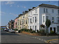
![Eastbourne houses [19]](https://s3.geograph.org.uk/geophotos/07/20/18/7201847_9718a8f1_120x120.jpg)
Eastbourne houses [19]
Odd numbers 35 to 49 Cavendish Place, seen here, and even numbers 36 to 48 Cavendish Place Image, were built in the early 1850s in a late Regency style and appear to be 30 years earlier. Constructed of stuccoed brick. There are iron balconies on the first floor. Listed, grade II, with details at: https://historicengland.org.uk/listing/the-list/list-entry/1190230
Eastbourne is a town and seaside resort on the south coast of East Sussex, some 54 miles south of London and about 19 miles east of Brighton. Although there is evidence of settlement from the Stone Age onwards, Eastbourne remained an area of small rural settlements until the railway arrived in 1849. A resort, built "for gentlemen by gentlemen", was planned and the town's growth accelerated from a population of less than 4,000 in 1851 to nearly 35,000 by 1891. Tourism is a large and important part of the economy of the town.
Image: © Michael Dibb
Taken: 5 May 2022
0.05 miles
8
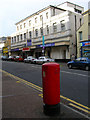
The Nut House, Seaside Road, Eastbourne
Image: © PAUL FARMER
Taken: 14 Jun 2014
0.05 miles
9
![Eastbourne houses [18]](https://s3.geograph.org.uk/geophotos/07/20/18/7201843_9a2ed186_120x120.jpg)
Eastbourne houses [18]
Numbers 25 to 33 Cavendish Place were built in the early 1850s in a late Regency style and appear to be 30 years earlier. Constructed of stuccoed brick. There are iron balconies on the first floor. Listed, grade II, with details at: https://historicengland.org.uk/listing/the-list/list-entry/1043669
Eastbourne is a town and seaside resort on the south coast of East Sussex, some 54 miles south of London and about 19 miles east of Brighton. Although there is evidence of settlement from the Stone Age onwards, Eastbourne remained an area of small rural settlements until the railway arrived in 1849. A resort, built "for gentlemen by gentlemen", was planned and the town's growth accelerated from a population of less than 4,000 in 1851 to nearly 35,000 by 1891. Tourism is a large and important part of the economy of the town.
Image: © Michael Dibb
Taken: 5 May 2022
0.06 miles