IMAGES TAKEN NEAR TO
Pevensey Road, EASTBOURNE, BN21 3HH
Introduction
This page details the photographs taken nearby to Pevensey Road, BN21 3HH by members of the Geograph project.
The Geograph project started in 2005 with the aim of publishing, organising and preserving representative images for every square kilometre of Great Britain, Ireland and the Isle of Man.

There are currently over 7.5m images from over14,400 individuals and you can help contribute to the project by visiting https://www.geograph.org.uk
Image Map
Images are licensed for reuse under creativecommons.org/licenses/by-sa/2.0
Notes
- Clicking on the map will re-center to the selected point.
- The higher the marker number, the further away the image location is from the centre of the postcode.
Image Listing (656 Images Found)
Images are licensed for reuse under creativecommons.org/licenses/by-sa/2.0
Image
Details
Distance
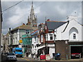
2
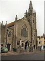
Central Methodist Church Eastbourne
Church is in Pevensey Road
Image: © PAUL FARMER
Taken: 17 Jul 2009
0.02 miles
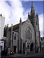
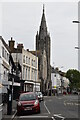
3
Central Methodist Church
Grade II listed Methodist Church, hall and school by Carlos Crisford in 1907, on the corner of Pevensey Road and Susan's Road
Image: © Richard Croft
Taken: 15 Jun 2013
0.02 miles
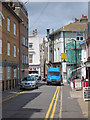
5
Caf? on North Street
A quiet one way back street between Seaside Road and Lismore Road.
Image: © Oast House Archive
Taken: 23 Jun 2011
0.02 miles
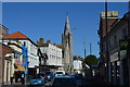
7
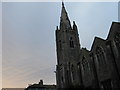
![Eastbourne churches [11]](https://s3.geograph.org.uk/geophotos/07/20/18/7201851_3f7dbd7f_120x120.jpg)
Eastbourne churches [11]
Within the block bounded by Pevensey Road, Langley Road and Susan's Road stands the Central Methodist church, the church hall and church school, all dated 1907. The church has its main entrance in Pevensey Road, the hall has its main entrance in Langney Road and both have elevations along Susan's Road. Both church and hall are built in the Decorated style of coursed rubble stone with ashlar dressings under a renewed pantile roof. Some original internal features remain. See also Image and Image Listed, grade II, with details at: https://historicengland.org.uk/listing/the-list/list-entry/1268358
Eastbourne is a town and seaside resort on the south coast of East Sussex, some 54 miles south of London and about 19 miles east of Brighton. Although there is evidence of settlement from the Stone Age onwards, Eastbourne remained an area of small rural settlements until the railway arrived in 1849. A resort, built "for gentlemen by gentlemen", was planned and the town's growth accelerated from a population of less than 4,000 in 1851 to nearly 35,000 by 1891. Tourism is a large and important part of the economy of the town.
Image: © Michael Dibb
Taken: 3 May 2022
0.02 miles
8
North Street
Quiet one way back street between Seaside Road and Lismore Road.
Image: © Oast House Archive
Taken: 23 Jun 2011
0.02 miles
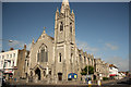
9
Central Methodist Church
Grade II listed. http://www.britishlistedbuildings.co.uk/101268358-central-methodist-church-former-hall-and-school-and-attached-walls-eastbourne
Image: © N Chadwick
Taken: 11 Sep 2016
0.02 miles
10
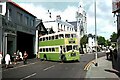
Leaving the bus station, Pevensey Road, Eastbourne ? 1972
The centre of Southdown Motor Services operations in Eastbourne, the bus station (with garage) dates probably from the 1930s. It has since been converted into a night club.
The bus is one of the iconic Southdown Leyland PD3 double-deckers with full width driver's cab, known as 'Queen Marys'. Body built by Northern Counties, with the distinctive short bay in the centre of the body. No.267 was built in 1965.
This is one of a series of views featuring buses in the 60s, 70s, and 80s.
http://www.geograph.org.uk/search.php?i=2114547&displayclass=slide
Image: © Alan Murray-Rust
Taken: 5 Aug 1972
0.02 miles