IMAGES TAKEN NEAR TO
Arndale Centre, EASTBOURNE, BN21 3FD
Introduction
This page details the photographs taken nearby to Arndale Centre, BN21 3FD by members of the Geograph project.
The Geograph project started in 2005 with the aim of publishing, organising and preserving representative images for every square kilometre of Great Britain, Ireland and the Isle of Man.

There are currently over 7.5m images from over14,400 individuals and you can help contribute to the project by visiting https://www.geograph.org.uk
Image Map
Images are licensed for reuse under creativecommons.org/licenses/by-sa/2.0
Notes
- Clicking on the map will re-center to the selected point.
- The higher the marker number, the further away the image location is from the centre of the postcode.
Image Listing (373 Images Found)
Images are licensed for reuse under creativecommons.org/licenses/by-sa/2.0
Image
Details
Distance
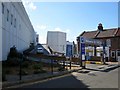
1
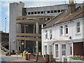
Tideswell Road
The curved exit ramp of a large multi storey car park seen behind the terraced houses.
Image: © Oast House Archive
Taken: 23 Jun 2011
0.01 miles
4
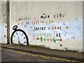
Wall artwork at 26 Longstone Road
Image: © Oast House Archive
Taken: 3 Jun 2019
0.04 miles
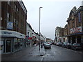
7
Susan's Road
The one way road is part of the A259 and town centre ring road.
Image: © Oast House Archive
Taken: 23 Jun 2011
0.07 miles