IMAGES TAKEN NEAR TO
Kings Drive, EASTBOURNE, BN21 2YB
Introduction
This page details the photographs taken nearby to Kings Drive, BN21 2YB by members of the Geograph project.
The Geograph project started in 2005 with the aim of publishing, organising and preserving representative images for every square kilometre of Great Britain, Ireland and the Isle of Man.

There are currently over 7.5m images from over14,400 individuals and you can help contribute to the project by visiting https://www.geograph.org.uk
Image Map (Loading...)


Getting Data...Please wait
Leaflet Map data © OpenStreetMap
Images are licensed for reuse under creativecommons.org/licenses/by-sa/2.0
Notes
- Clicking on the map will re-center to the selected point.
- The higher the marker number, the further away the image location is from the centre of the postcode.
Image Listing (20 Images Found)
Images are licensed for reuse under creativecommons.org/licenses/by-sa/2.0
Image
Details
Distance
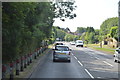
1
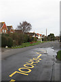
Park Lane
Built originally to link Ratton Manor with its wooded parklands that is now Hampden Park. The road has also become residential linking Decoy Roundabout on the A2021 with Willingdon Road, the A2270.
Image: © Simon Carey
Taken: 24 Jan 2009
0.12 miles
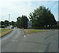
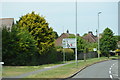
3
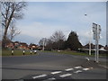
Roundabout, Willingdon Rd
The junction of the A2270 & A2021.
Image: © N Chadwick
Taken: 31 Mar 2011
0.13 miles
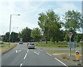
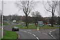
6
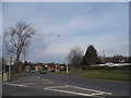
The Willingdon Roundabout from the southern approach
Image: © David Howard
Taken: 3 Apr 2016
0.15 miles