IMAGES TAKEN NEAR TO
Ocklynge Avenue, EASTBOURNE, BN21 2QD
Introduction
This page details the photographs taken nearby to Ocklynge Avenue, BN21 2QD by members of the Geograph project.
The Geograph project started in 2005 with the aim of publishing, organising and preserving representative images for every square kilometre of Great Britain, Ireland and the Isle of Man.

There are currently over 7.5m images from over14,400 individuals and you can help contribute to the project by visiting https://www.geograph.org.uk
Image Map
Images are licensed for reuse under creativecommons.org/licenses/by-sa/2.0
Notes
- Clicking on the map will re-center to the selected point.
- The higher the marker number, the further away the image location is from the centre of the postcode.
Image Listing (192 Images Found)
Images are licensed for reuse under creativecommons.org/licenses/by-sa/2.0
Image
Details
Distance
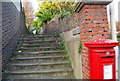
1
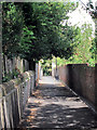
Ocklynge Avenue
Alleyway between Upperton Road and Mill Road (ahead).
Image: © Oast House Archive
Taken: 16 Aug 2011
0.02 miles
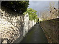
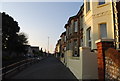
9
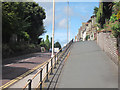
Raised footpath along Willingdon Road
Image: © Oast House Archive
Taken: 16 Aug 2011
0.07 miles
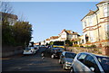
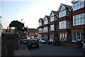
10
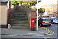
Postbox, corner of Willingdon Rd and Selwyn Rd
Image: © N Chadwick
Taken: 14 Apr 2010
0.07 miles