IMAGES TAKEN NEAR TO
Laleham Close, EASTBOURNE, BN21 2LQ
Introduction
This page details the photographs taken nearby to Laleham Close, BN21 2LQ by members of the Geograph project.
The Geograph project started in 2005 with the aim of publishing, organising and preserving representative images for every square kilometre of Great Britain, Ireland and the Isle of Man.

There are currently over 7.5m images from over14,400 individuals and you can help contribute to the project by visiting https://www.geograph.org.uk
Image Map
Images are licensed for reuse under creativecommons.org/licenses/by-sa/2.0
Notes
- Clicking on the map will re-center to the selected point.
- The higher the marker number, the further away the image location is from the centre of the postcode.
Image Listing (286 Images Found)
Images are licensed for reuse under creativecommons.org/licenses/by-sa/2.0
Image
Details
Distance
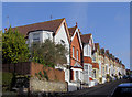
8
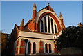
United Reformed Church, Upperton Rd
Formerly the congregational church. Built in 1885.
Image: © N Chadwick
Taken: 14 Apr 2010
0.04 miles
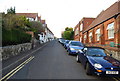
10
Watts Lane, Eastbourne, East Sussex
Row of Victorian houses on the steep hill of Watts Lane
Image: © Kevin Gordon
Taken: 29 Mar 2008
0.04 miles