IMAGES TAKEN NEAR TO
Albert Terrace, EASTBOURNE, BN21 1ST
Introduction
This page details the photographs taken nearby to Albert Terrace, BN21 1ST by members of the Geograph project.
The Geograph project started in 2005 with the aim of publishing, organising and preserving representative images for every square kilometre of Great Britain, Ireland and the Isle of Man.

There are currently over 7.5m images from over14,400 individuals and you can help contribute to the project by visiting https://www.geograph.org.uk
Image Map
Images are licensed for reuse under creativecommons.org/licenses/by-sa/2.0
Notes
- Clicking on the map will re-center to the selected point.
- The higher the marker number, the further away the image location is from the centre of the postcode.
Image Listing (61 Images Found)
Images are licensed for reuse under creativecommons.org/licenses/by-sa/2.0
Image
Details
Distance
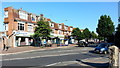
2

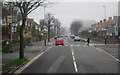
Green Street
Line of shops at the north end of Green Street.
Image: © Oast House Archive
Taken: 15 Sep 2011
0.02 miles
4
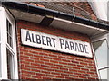
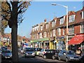
Albert Parade, Green Street, Eastbourne
The parade of shops was built in the early twentieth century. The sign is the original.
Image: © nick macneill
Taken: 30 Nov 2010
0.03 miles
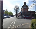
6
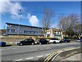
Row of shops, Downside, Eastbourne
The TV/TQ myriad grid line passes across the street to the right roughly on the end of the Co-op store.
Image: © Jonathan Billinger
Taken: 6 Jul 2015
0.03 miles
7
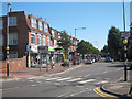
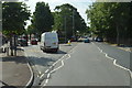
Green Street
Line of shops at the north end of Green Street at Victoria Drive junction.
Image: © Oast House Archive
Taken: 15 Sep 2011
0.03 miles