IMAGES TAKEN NEAR TO
Crown Street, EASTBOURNE, BN21 1NZ
Introduction
This page details the photographs taken nearby to Crown Street, BN21 1NZ by members of the Geograph project.
The Geograph project started in 2005 with the aim of publishing, organising and preserving representative images for every square kilometre of Great Britain, Ireland and the Isle of Man.

There are currently over 7.5m images from over14,400 individuals and you can help contribute to the project by visiting https://www.geograph.org.uk
Image Map
Images are licensed for reuse under creativecommons.org/licenses/by-sa/2.0
Notes
- Clicking on the map will re-center to the selected point.
- The higher the marker number, the further away the image location is from the centre of the postcode.
Image Listing (335 Images Found)
Images are licensed for reuse under creativecommons.org/licenses/by-sa/2.0
Image
Details
Distance
1
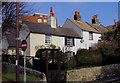
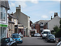
Cottages in Watts Lane, Eastbourne, East Sussex
At the junction of Watts Lane and Upperton Road
Image: © Kevin Gordon
Taken: 29 Mar 2008
0.03 miles
2
Eastbourne old fire station 5
Eastbourne old fire station 5, 5 Watts Lane, Eastbourne, East Sussex
Image: © Kevin Hale
Taken: 28 Jun 2010
0.03 miles
4
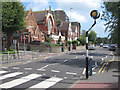
Upperton Road
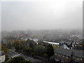
A2270 main road into Eastbourne.
Image: © Oast House Archive
Taken: 16 Aug 2011
0.04 miles
6

Russells Cottages, Watts Lane, Eastbourne
Image: © PAUL FARMER
Taken: 9 Dec 2013
0.04 miles
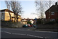
7
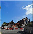
Demolition of Upperton United Reformed Church
Image: © PAUL FARMER
Taken: 29 Aug 2019
0.04 miles

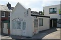
10
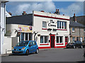
The Crown, Eastbourne
Pub on Crown Street.
Image: © Oast House Archive
Taken: 16 Aug 2011
0.05 miles