IMAGES TAKEN NEAR TO
New Upperton Road, EASTBOURNE, BN21 1NN
Introduction
This page details the photographs taken nearby to New Upperton Road, BN21 1NN by members of the Geograph project.
The Geograph project started in 2005 with the aim of publishing, organising and preserving representative images for every square kilometre of Great Britain, Ireland and the Isle of Man.

There are currently over 7.5m images from over14,400 individuals and you can help contribute to the project by visiting https://www.geograph.org.uk
Image Map
Images are licensed for reuse under creativecommons.org/licenses/by-sa/2.0
Notes
- Clicking on the map will re-center to the selected point.
- The higher the marker number, the further away the image location is from the centre of the postcode.
Image Listing (331 Images Found)
Images are licensed for reuse under creativecommons.org/licenses/by-sa/2.0
Image
Details
Distance
1
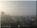
Foggy Morning in Upperton Road, Eastbourne
Image: © PAUL FARMER
Taken: 5 Apr 2014
0.02 miles
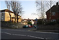
4
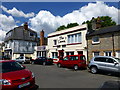
The Crown Public House, Crown Street, Eastbourne
Image: © PAUL FARMER
Taken: 25 May 2013
0.03 miles
5
Eastbourne old fire station 5
Eastbourne old fire station 5, 5 Watts Lane, Eastbourne, East Sussex
Image: © Kevin Hale
Taken: 28 Jun 2010
0.03 miles
6

Russells Cottages, Watts Lane, Eastbourne
Image: © PAUL FARMER
Taken: 9 Dec 2013
0.03 miles
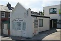
7
![Eastbourne buildings [64]](https://s2.geograph.org.uk/geophotos/07/22/02/7220222_bbee94cf_120x120.jpg)
Eastbourne buildings [64]
Formerly The Court House, now The Rainbow public house, this early 17th century house in Moatcroft Road occupies the site of a medieval manor courthouse. Timber framed, encased in cobbles, under a tile roof. Partly rebuilt in 1878. Some oak panelling remains inside. There is another view of the building at Image Listed, grade II, with details at: https://historicengland.org.uk/listing/the-list/list-entry/1043655
Eastbourne is a town and seaside resort on the south coast of East Sussex, some 54 miles south of London and about 19 miles east of Brighton. Although there is evidence of settlement from the Stone Age onwards, Eastbourne remained an area of small rural settlements until the railway arrived in 1849. A resort, built "for gentlemen by gentlemen", was planned and the town's growth accelerated from a population of less than 4,000 in 1851 to nearly 35,000 by 1891. Tourism is a large and important part of the economy of the town.
Image: © Michael Dibb
Taken: 9 May 2022
0.04 miles
8
![Eastbourne buildings [65]](https://s3.geograph.org.uk/geophotos/07/22/02/7220223_e0f775c2_120x120.jpg)
Eastbourne buildings [65]
Formerly The Court House, now The Rainbow public house, this early 17th century house in Moatcroft Road occupies the site of a medieval manor courthouse. Timber framed, encased in cobbles, under a tile roof. Partly rebuilt in 1878. Some oak panelling remains inside. There is another view of the building at Image Listed, grade II, with details at: https://historicengland.org.uk/listing/the-list/list-entry/1043655
Eastbourne is a town and seaside resort on the south coast of East Sussex, some 54 miles south of London and about 19 miles east of Brighton. Although there is evidence of settlement from the Stone Age onwards, Eastbourne remained an area of small rural settlements until the railway arrived in 1849. A resort, built "for gentlemen by gentlemen", was planned and the town's growth accelerated from a population of less than 4,000 in 1851 to nearly 35,000 by 1891. Tourism is a large and important part of the economy of the town.
Image: © Michael Dibb
Taken: 9 May 2022
0.04 miles