IMAGES TAKEN NEAR TO
Upperton Road, EASTBOURNE, BN21 1LP
Introduction
This page details the photographs taken nearby to Upperton Road, BN21 1LP by members of the Geograph project.
The Geograph project started in 2005 with the aim of publishing, organising and preserving representative images for every square kilometre of Great Britain, Ireland and the Isle of Man.

There are currently over 7.5m images from over14,400 individuals and you can help contribute to the project by visiting https://www.geograph.org.uk
Image Map
Images are licensed for reuse under creativecommons.org/licenses/by-sa/2.0
Notes
- Clicking on the map will re-center to the selected point.
- The higher the marker number, the further away the image location is from the centre of the postcode.
Image Listing (337 Images Found)
Images are licensed for reuse under creativecommons.org/licenses/by-sa/2.0
Image
Details
Distance
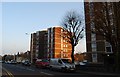
4
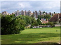
Blocks of flats in Upperton Road, Eastbourne
Picture is taken from St Mary's Churchyard
Image: © PAUL FARMER
Taken: 15 Sep 2013
0.04 miles
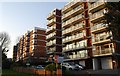
6
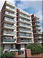
Alfriston House
Block of flats by Upperton Road.
Image: © Oast House Archive
Taken: 16 Aug 2011
0.05 miles
7
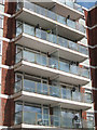
Alfriston House
Glazed balconies on a block of flats by Upperton Road.
See Image
Image: © Oast House Archive
Taken: 16 Aug 2011
0.05 miles
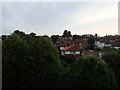
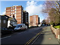
8
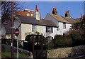
Cottages in Watts Lane, Eastbourne, East Sussex
At the junction of Watts Lane and Upperton Road
Image: © Kevin Gordon
Taken: 29 Mar 2008
0.05 miles