IMAGES TAKEN NEAR TO
Compton Place Road, EASTBOURNE, BN21 1EA
Introduction
This page details the photographs taken nearby to Compton Place Road, BN21 1EA by members of the Geograph project.
The Geograph project started in 2005 with the aim of publishing, organising and preserving representative images for every square kilometre of Great Britain, Ireland and the Isle of Man.

There are currently over 7.5m images from over14,400 individuals and you can help contribute to the project by visiting https://www.geograph.org.uk
Image Map
Images are licensed for reuse under creativecommons.org/licenses/by-sa/2.0
Notes
- Clicking on the map will re-center to the selected point.
- The higher the marker number, the further away the image location is from the centre of the postcode.
Image Listing (180 Images Found)
Images are licensed for reuse under creativecommons.org/licenses/by-sa/2.0
Image
Details
Distance
2
Neo Georgian houses on Meads Road, Eastbourne
These were very popular in the 70s. George and Mildred lived in similar ones.
Image: © David Howard
Taken: 3 Apr 2016
0.02 miles
3
![Eastbourne houses [23]](https://s3.geograph.org.uk/geophotos/07/21/74/7217475_b6afdd4f_120x120.jpg)
Eastbourne houses [23]
Greystone Haugh, number 18 Meads Road, (nearer the camera) and Greystone House, number, 20 Meads Road, were originally one house becoming two when the extension was added. Built in the 18th century of cobbles and brick under a slate roof. Listed, grade II, with details at: https://historicengland.org.uk/listing/the-list/list-entry/1353138
Eastbourne is a town and seaside resort on the south coast of East Sussex, some 54 miles south of London and about 19 miles east of Brighton. Although there is evidence of settlement from the Stone Age onwards, Eastbourne remained an area of small rural settlements until the railway arrived in 1849. A resort, built "for gentlemen by gentlemen", was planned and the town's growth accelerated from a population of less than 4,000 in 1851 to nearly 35,000 by 1891. Tourism is a large and important part of the economy of the town.
Image: © Michael Dibb
Taken: 7 May 2022
0.02 miles
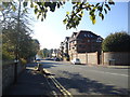
4
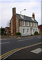
The Grey House, Meads Road
On the corner of Meads Road and Compton Place Road. Probably built in relation to Compton Place, the Eastbourne home of the Dukes of Devonshire. Beyond it is The Saffrons cricket and football ground.
Image: © Simon Carey
Taken: 3 Feb 2008
0.03 miles
5
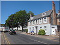
Greystone House
Grade II listed http://list.english-heritage.org.uk/resultsingle.aspx?uid=1353138 render and flint house, now split into two houses.
Image: © Oast House Archive
Taken: 23 Jul 2012
0.03 miles
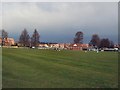
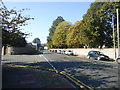
9
![Eastbourne features [47]](https://s3.geograph.org.uk/geophotos/07/21/64/7216447_ceb8d675_120x120.jpg)
Eastbourne features [47]
Seen from the Compton Place Road entrance, The Saffrons sports ground is the home of Eastbourne Cricket Club.
Eastbourne is a town and seaside resort on the south coast of East Sussex, some 54 miles south of London and about 19 miles east of Brighton. Although there is evidence of settlement from the Stone Age onwards, Eastbourne remained an area of small rural settlements until the railway arrived in 1849. A resort, built "for gentlemen by gentlemen", was planned and the town's growth accelerated from a population of less than 4,000 in 1851 to nearly 35,000 by 1891. Tourism is a large and important part of the economy of the town.
Image: © Michael Dibb
Taken: 7 May 2022
0.06 miles
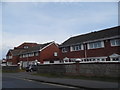
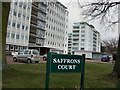
10
Saffrons Court, Compton Place Road, Eastbourne
Image: © PAUL FARMER
Taken: 31 Dec 2020
0.06 miles