IMAGES TAKEN NEAR TO
Marine View, BRIGHTON, BN2 0HH
Introduction
This page details the photographs taken nearby to Marine View, BN2 0HH by members of the Geograph project.
The Geograph project started in 2005 with the aim of publishing, organising and preserving representative images for every square kilometre of Great Britain, Ireland and the Isle of Man.

There are currently over 7.5m images from over14,400 individuals and you can help contribute to the project by visiting https://www.geograph.org.uk
Image Map
Images are licensed for reuse under creativecommons.org/licenses/by-sa/2.0
Notes
- Clicking on the map will re-center to the selected point.
- The higher the marker number, the further away the image location is from the centre of the postcode.
Image Listing (280 Images Found)
Images are licensed for reuse under creativecommons.org/licenses/by-sa/2.0
Image
Details
Distance
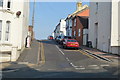
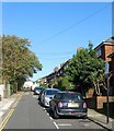
2
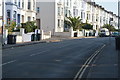
Sussex Street
Head south down Windmill Street then east down Sussex Street. This is looking at its junction with Queens Park Road and is the opposite view to the one Bob Embleton took for this square.
Click on the link to take you to the next page. http://www.geograph.org.uk/photo/232042
Image: © Simon Carey
Taken: 1 Sep 2006
0.02 miles
3
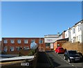
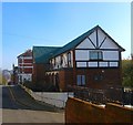
Zylo Works, Marine View, Brighton
Tucked away on the corner of Marine View and Park Road Terrace is one of the few manufacturing centres left in the centre of the city. The Zylo Works were established by Malby & Co formed 1810, a London firm, after the First World War to manufacturer nameplates. The works were extended during the 1930s and became the headquarters of the firm during the Second World War when they moved all production here to escape the blitz. During the conflict they made items for aircraft and maintained close links with the aerospace industry after. Still producing nameplates today under the London Name Plate Company and still run by the same family. The factory was one of the few buildings to survive along with the terrace to the right when the area bounded by St John's Place, Carlton Hill, Upper Park Place and Sussex Street was cleared of slum housing in the 1960s. Carlton Place, whose nameplate can be seen in the foreground was one of the streets completely demolished and replaced with flats truncating the street in the process.
Image: © Simon Carey
Taken: 1 Nov 2015
0.03 miles
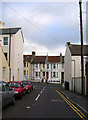
5
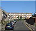
Lennox Street, Brighton
The street originally ran from Carlton Street to Sussex Street and was developed in the 1840s but was demolished around 1962 removing the northern end at the junction with Sussex Street turning the road into a cul de sac. See http://regencysociety-jamesgray.com/volume24/source/jg_24_150.html for a 1962 pre-demolition view.
Image: © Simon Carey
Taken: 1 Nov 2015
0.03 miles
6
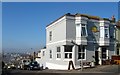
The Setting Sun, Windmill Street, Brighton
Located on the corner of Sussex Street the public house opened in the late 1860s as the Millers Arms. Brighton Station can be seen in the far distance on the western side of the valley.
Image: © Simon Carey
Taken: 1 Nov 2015
0.04 miles
7
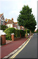
West Drive
Go through the gate and head a little north up West Drive. These villas were added between 1900-04 and overlook Queens Park which is to the right of the picture. The red brick Edwardian villas can fool you into thinking you are in Hove.
Click on the link to take you to the next page. http://www.geograph.org.uk/photo/232055
Image: © Simon Carey
Taken: 1 Sep 2006
0.04 miles
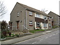
8
Parks View, Upper Park Place, Brighton
The flats date from the mid 1960s and were originally the rebuilt Red Lion public house which closed around ten years ago. The original pub opened in the 1850s and was rebuilt when the area was largely cleared of housing, see http://regencysociety-jamesgray.com/volume24/source/jg_24_150.html for a view of the former pub building.
Image: © Simon Carey
Taken: 1 Nov 2015
0.05 miles
9
St John's Place, Brighton
Originally a cul de sac containing terraced cottages built in the 1820s. These were removed in 1937 and replaced with new council housing as well as extending the street northwards to Sussex Street across the former gardens of St John's Lodge that the council had acquired in 1933.
Image: © Simon Carey
Taken: 1 Nov 2015
0.05 miles