IMAGES TAKEN NEAR TO
College Terrace, BRIGHTON, BN2 0EX
Introduction
This page details the photographs taken nearby to College Terrace, BN2 0EX by members of the Geograph project.
The Geograph project started in 2005 with the aim of publishing, organising and preserving representative images for every square kilometre of Great Britain, Ireland and the Isle of Man.

There are currently over 7.5m images from over14,400 individuals and you can help contribute to the project by visiting https://www.geograph.org.uk
Image Map
Images are licensed for reuse under creativecommons.org/licenses/by-sa/2.0
Notes
- Clicking on the map will re-center to the selected point.
- The higher the marker number, the further away the image location is from the centre of the postcode.
Image Listing (155 Images Found)
Images are licensed for reuse under creativecommons.org/licenses/by-sa/2.0
Image
Details
Distance
1
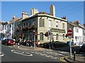
The Round Georges, Sutherland Road, Brighton
Built in the late 1870s with much of the surrounding houses and known as the Sutherland Arms up until about 2006-07 when it acquired its current title. Located on the corner of Canning Street.
Image: © Simon Carey
Taken: 11 Oct 2015
0.02 miles
2
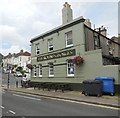
The Round Georges Pub. Brighton
website: http://www.theroundgeorgesbrighton.com/
Image: © Paul Gillett
Taken: 20 Jul 2014
0.02 miles
3
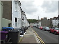
Canning Street
Near to Brighton College in the Kemp Town area of Brighton
Image: © Paul Gillett
Taken: 20 Jul 2014
0.05 miles
4
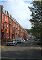
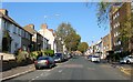
College Terrace, Brighton
A residential road that runs from Sutherland Road to Walpole Terrace that was built in the early 1880s and overlooks Image which was already in place prior to their construction.
Image: © Simon Carey
Taken: 4 Oct 2015
0.06 miles
5
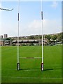
Playing Fields, Brighton College, Brighton
A view of the rugby pitch at the northern end of the fields from Walpole Terrace. The Japanese rugby team were based here prior to their game with South Africa during the 2015 Rugby World Cup.
Image: © Simon Carey
Taken: 4 Oct 2015
0.06 miles
6
Sutherland Road, Brighton
The road runs north from Eastern Road becoming Queensway beyond the tree on the right in the far distance where it continues up to the racecourse. The flats on the right are St Matthews Court built on the site of St Matthews Church which was closed in 1962 and demolished in 1967.
Image: © Simon Carey
Taken: 11 Oct 2015
0.06 miles
7
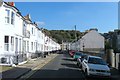
Canning Street, Brighton
A residential road that links Suitherland Road to Walpole Terrace that was developed in the early 1860s.
Image: © Simon Carey
Taken: 11 Oct 2015
0.07 miles
8
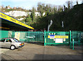
Storage King, Freshfield Industrial Estate
Not the greatest of pictures as taken over a gate without any viewing aid. The interest lies mainly beyond the second gate, namely the southern portal of Kemp Town Tunnel the only remaining item to remind you that the area was once the terminus of a small branch railway. The Kemp Town branch opened in 1869 though it closed to traffic in 1932 losing out on the easier and cheaper journey by bus. However, it remained open to goods until its final closure in 1971. The tunnel was used during the war to shelter both railway stock and people and after its closure was used for a while to grow mushrooms and store motor vehicles. The cliffs beyond give some idea of the bowl shaped out of the downland by the railway and also the engineering required to build a branch. Despite being 1 mile and 726 yards long the line required a 180 yard viaduct over Lewes Road, a shorter three arch viaduct over Hartington Road, followed by a short cutting before entering the 1024 yard long Kemp Town Tunnel and exiting into this bowl towards the terminus.
Image: © Simon Carey
Taken: 11 Jan 2009
0.07 miles
9
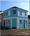
Former Pub, Bute Street, Brighton
The Bute Arms was located on the corner of Bute Street and Livingstone Street and was built with the street in the late 1870s. It closed in 1962 and was converted into a corner shop which has since closed too. Now a couple of dwellings.
Image: © Simon Carey
Taken: 11 Oct 2015
0.07 miles
10
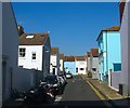
Livingstone Street, Brighton
A side street that runs from Image to Image crossing Image in the process. The blue building on the right is Image and looks to be the only dwelling on the street.
Image: © Simon Carey
Taken: 11 Oct 2015
0.08 miles