IMAGES TAKEN NEAR TO
The Graperies, BRIGHTON, BN2 0BW
Introduction
This page details the photographs taken nearby to The Graperies, BN2 0BW by members of the Geograph project.
The Geograph project started in 2005 with the aim of publishing, organising and preserving representative images for every square kilometre of Great Britain, Ireland and the Isle of Man.

There are currently over 7.5m images from over14,400 individuals and you can help contribute to the project by visiting https://www.geograph.org.uk
Image Map
Images are licensed for reuse under creativecommons.org/licenses/by-sa/2.0
Notes
- Clicking on the map will re-center to the selected point.
- The higher the marker number, the further away the image location is from the centre of the postcode.
Image Listing (327 Images Found)
Images are licensed for reuse under creativecommons.org/licenses/by-sa/2.0
Image
Details
Distance
1
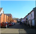
The Graperies, Brighton
A cul de sac off Park Street built on the site of the former Southdown Coach Depot which operated from here from 1915 until its closure in the 1990s. The name derives from a market garden to the north known as The Graperies and now part of Image
Image: © Simon Carey
Taken: 1 Nov 2015
0.01 miles
2
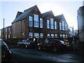
Queens Park Primary School
Located south of Queens Park, Website: http://www.queenspark.brighton-hove.sch.uk/
Image: © Paul Gillett
Taken: 1 Jan 2013
0.01 miles
3
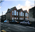
Queens Park Primary School
website: http://www.queenspark.brighton-hove.sch.uk/
Image: © Paul Gillett
Taken: 25 Dec 2018
0.02 miles
4
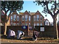
Queen's Park Primary School, Park Street, Brighton
Built as Freshfield Place Brighton Board School in 1880 it later became Queen's Park Secondary School until it was merged with Whitehawk during the mid 1970s. Since then it has been a primary school.
Image: © Simon Carey
Taken: 1 Nov 2015
0.02 miles
5
Park Street Gates
southern entrance to Queens Park
Image: © Paul Gillett
Taken: 31 Jul 2010
0.03 miles
6
Freshfield Place, Brighton
A residential road that links Freshfield Road to Park Street the road was developed in the late 1890s though much of the southern side has been rebuilt. The houses on the left were built on the site of a former bus depot and are currently part of Image
Image: © Simon Carey
Taken: 4 Oct 2015
0.03 miles
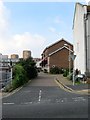
8
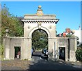
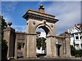
Park Street Gate, Queen's Park, Brighton
An arched gate was placed at the entrance to the park from Park Street when Thomas Attree opened the original park in 1829. It was rebuilt in 1890 with the name of the Race Stand Trustees, the group who purchased the park for public use, added along the top. Today the gate acts as an entrance to South Drive which was developed with housing in the first decade of the 20th century.
One of two, see also Image
Image: © Simon Carey
Taken: 1 Nov 2015
0.05 miles
9
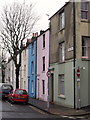
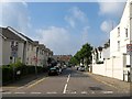
Pastelled houses in Park Street, Brighton
Image: © nick macneill
Taken: 11 Feb 2011
0.05 miles
10
Southdown Mews, Brighton
A cul de sac off Freshfield Road that was built on the site of a former Southdown bus depot that existed here from 1915 until its closure in 1991.
Image: © Simon Carey
Taken: 4 Oct 2015
0.05 miles