IMAGES TAKEN NEAR TO
Gorringe Valley Road, EASTBOURNE, BN20 9SX
Introduction
This page details the photographs taken nearby to Gorringe Valley Road, BN20 9SX by members of the Geograph project.
The Geograph project started in 2005 with the aim of publishing, organising and preserving representative images for every square kilometre of Great Britain, Ireland and the Isle of Man.

There are currently over 7.5m images from over14,400 individuals and you can help contribute to the project by visiting https://www.geograph.org.uk
Image Map
Images are licensed for reuse under creativecommons.org/licenses/by-sa/2.0
Notes
- Clicking on the map will re-center to the selected point.
- The higher the marker number, the further away the image location is from the centre of the postcode.
Image Listing (27 Images Found)
Images are licensed for reuse under creativecommons.org/licenses/by-sa/2.0
Image
Details
Distance
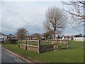
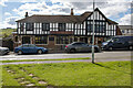
2
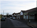
Shops, Gorringe Valley Road
Only the hair saloon is open on a Saturday morning, the rest are made up of a vets, a dog grooming service, bathroom showroom, beauty saloon and Willingdon & Jevington parish council offices. The junction with Eastbourne Road, the A2270 is at the end of the parade.
Image: © Simon Carey
Taken: 24 Jan 2009
0.06 miles
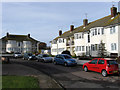
4
Gorringe Drive
Small cul-de-sac of 1950s bungalows off Gorringe Valley Road.
Image: © Simon Carey
Taken: 24 Jan 2009
0.07 miles
6
The Triangle, Willingdon
The village green for Willingdon.
Image: © N Chadwick
Taken: 31 Mar 2011
0.08 miles
7
Mewett's Court, Meachants Lane
Blocks of flats on a small cul-de-sac off the A2270.
Image: © Simon Carey
Taken: 24 Jan 2009
0.08 miles
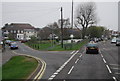
8
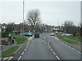
The British Queen Public House car park, Lower Willingdon, East Sussex
The photo shows the car park for the British Queen Public House. The flagpole at the entrance is flying a half-mast Union Jack in honour and respect to Her Majesty Queen Elizabeth II.
Image: © Andrew Diack
Taken: 18 Sep 2022
0.08 miles
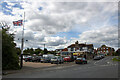
9
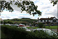
The British Queen pub, carpark and flagpole, Willingdon, East Sussex
This view encompasses the British Queen Public House, its car park and flagpole.
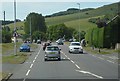
The Union Jack flag is seen flying at half-mast during the 10-day period of mourning for Her Majesty Queen Elizabeth II. The hills in the distance show a scarp face of the South Downs including the steep slopes leading to Cold Crouch and Coombe Hill.
Image: © Andrew Diack
Taken: 18 Sep 2022
0.09 miles
10
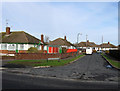
British Queen Public House in The Triangle, Willingdon, East Sussex
The British Queen Public House lies in Lower Willingdon, on the outskirts of Eastbourne, and at the foot of the South Downs.
Image: © Andrew Diack
Taken: 18 Sep 2022
0.10 miles