IMAGES TAKEN NEAR TO
Gorringe Close, EASTBOURNE, BN20 9SU
Introduction
This page details the photographs taken nearby to Gorringe Close, BN20 9SU by members of the Geograph project.
The Geograph project started in 2005 with the aim of publishing, organising and preserving representative images for every square kilometre of Great Britain, Ireland and the Isle of Man.

There are currently over 7.5m images from over14,400 individuals and you can help contribute to the project by visiting https://www.geograph.org.uk
Image Map
Images are licensed for reuse under creativecommons.org/licenses/by-sa/2.0
Notes
- Clicking on the map will re-center to the selected point.
- The higher the marker number, the further away the image location is from the centre of the postcode.
Image Listing (26 Images Found)
Images are licensed for reuse under creativecommons.org/licenses/by-sa/2.0
Image
Details
Distance
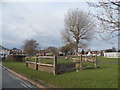
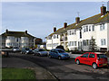
1
Gorringe Drive
Small cul-de-sac of 1950s bungalows off Gorringe Valley Road.
Image: © Simon Carey
Taken: 24 Jan 2009
0.06 miles
3
Public footpath off Meachants Lane, Willingdon
Image: © nick macneill
Taken: 19 Apr 2013
0.07 miles
4
Mewett's Court, Meachants Lane
Blocks of flats on a small cul-de-sac off the A2270.
Image: © Simon Carey
Taken: 24 Jan 2009
0.10 miles
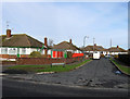
5
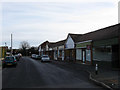
Shops, Gorringe Valley Road
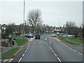
Only the hair saloon is open on a Saturday morning, the rest are made up of a vets, a dog grooming service, bathroom showroom, beauty saloon and Willingdon & Jevington parish council offices. The junction with Eastbourne Road, the A2270 is at the end of the parade.
Image: © Simon Carey
Taken: 24 Jan 2009
0.10 miles
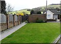
7
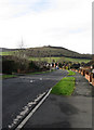
Coombe Rise
More bungalows but with the added backdrop of Coombe Hill.
Image: © Simon Carey
Taken: 24 Jan 2009
0.12 miles
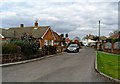
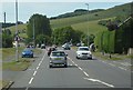
9
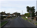
Gorringe Valley Road
An area of 1950s bungalow link the village of Willingdon with the hamlet of Wannock. The road itself starts at Eastbourne Road, the A2270, and finishes at Wannock Lane just out of shot in the distance.
Image: © Simon Carey
Taken: 24 Jan 2009
0.14 miles