IMAGES TAKEN NEAR TO
Gorringe Valley Road, EASTBOURNE, BN20 9SR
Introduction
This page details the photographs taken nearby to Gorringe Valley Road, BN20 9SR by members of the Geograph project.
The Geograph project started in 2005 with the aim of publishing, organising and preserving representative images for every square kilometre of Great Britain, Ireland and the Isle of Man.

There are currently over 7.5m images from over14,400 individuals and you can help contribute to the project by visiting https://www.geograph.org.uk
Image Map
Images are licensed for reuse under creativecommons.org/licenses/by-sa/2.0
Notes
- Clicking on the map will re-center to the selected point.
- The higher the marker number, the further away the image location is from the centre of the postcode.
Image Listing (22 Images Found)
Images are licensed for reuse under creativecommons.org/licenses/by-sa/2.0
Image
Details
Distance
1
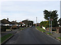
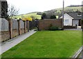
Gorringe Valley Road
An area of 1950s bungalow link the village of Willingdon with the hamlet of Wannock. The road itself starts at Eastbourne Road, the A2270, and finishes at Wannock Lane just out of shot in the distance.
Image: © Simon Carey
Taken: 24 Jan 2009
0.01 miles
3
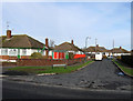
Gorringe Drive
Small cul-de-sac of 1950s bungalows off Gorringe Valley Road.
Image: © Simon Carey
Taken: 24 Jan 2009
0.13 miles
4
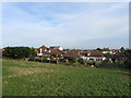
Bungalows, Wannock Lane
Viewed from the footpath that links Wannock to Willingdon.
Image: © Simon Carey
Taken: 24 Jan 2009
0.16 miles
5

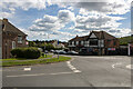
Lane above Willingdon
With views towards Hanging Hill
Image: © Andy Stephenson
Taken: 23 Jun 2014
0.20 miles
6
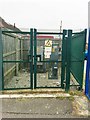
Electricity sub station, Rapson's Road
Image: © Alex McGregor
Taken: 10 Feb 2015
0.20 miles
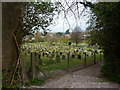
7
Public footpath off Meachants Lane, Willingdon
Image: © nick macneill
Taken: 19 Apr 2013
0.21 miles
9
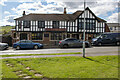
The British Queen Public House, Lower Willingdon, East Sussex
The photo shows the British Queen Public House in The Triangle, Lower Willingdon, East Sussex. The pub was originally a double fronted Georgian building, probably comprising two cottages. The mock Tudor façade was built in 1935, when it was part of the Star brewery estate, and the building was extended after being taken over by Courage brewery in 1965. Lying next to the pub is the car park and at the entrance to the car park the British Queen flagpole is flying a half-mast Union Jack in honour and respect of the passing of Her Majesty Queen Elizabeth II. Because of the name, the British Queen flagpole would seem a particularly fitting place from which to fly the half-mast flag.
Image: © Andrew Diack
Taken: 18 Sep 2022
0.22 miles
10
British Queen Public House in The Triangle, Willingdon, East Sussex
The British Queen Public House lies in Lower Willingdon, on the outskirts of Eastbourne, and at the foot of the South Downs.
Image: © Andrew Diack
Taken: 18 Sep 2022
0.22 miles