IMAGES TAKEN NEAR TO
Wish Hill, EASTBOURNE, BN20 9HN
Introduction
This page details the photographs taken nearby to Wish Hill, BN20 9HN by members of the Geograph project.
The Geograph project started in 2005 with the aim of publishing, organising and preserving representative images for every square kilometre of Great Britain, Ireland and the Isle of Man.

There are currently over 7.5m images from over14,400 individuals and you can help contribute to the project by visiting https://www.geograph.org.uk
Image Map
Images are licensed for reuse under creativecommons.org/licenses/by-sa/2.0
Notes
- Clicking on the map will re-center to the selected point.
- The higher the marker number, the further away the image location is from the centre of the postcode.
Image Listing (158 Images Found)
Images are licensed for reuse under creativecommons.org/licenses/by-sa/2.0
Image
Details
Distance
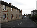
1
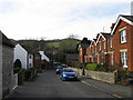
Church Street
Former village street of Willingdon a settlement swallowed up by the growth of Eastbourne during the 20th century. Looking down towards the junction with Coopers Hill with the Wheatsheaf pub on the left hand side.
Image: © Simon Carey
Taken: 24 Jan 2009
0.02 miles
2
![Willingdon houses [20]](https://s3.geograph.org.uk/geophotos/07/19/82/7198215_9c5d5f33_120x120.jpg)
Willingdon houses [20]
Malthouse Cottages, even numbers 128 to 134 Wish Hill, are four cottages set back to back. Dated 1826, constructed of knapped flint with red and vitrified brick quoins and dressings, all under a double hipped slate roof. Listed, grade II, with details at: https://historicengland.org.uk/listing/the-list/list-entry/1043615
Once isolated villages, Upper Willingdon and Lower Willingdon, are now part of the built-up area of Eastbourne. Set on a spur at the foot of the South Downs, the village lies astride the A22 road, about 1 mile south of Polegate. There is evidence of occupation since the pre-Saxon age.
Image: © Michael Dibb
Taken: 10 May 2022
0.03 miles
3
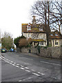
The Five Gables, Wish Hill
Sounding like a Sherlock Holmes adventure this Victorian flint house stands at the centre of the village, beyond it the road becomes Coopers Hill. Taken from the junction with Butts Lane.
Image: © Simon Carey
Taken: 24 Jan 2009
0.03 miles
4
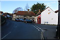
Midday New Year's Day, 2019, at Willingdon Post Office
This photo, taken at midday on New Year's Day 2019, shows Willingdon Post Office on Wish Hill.
Image: © Andrew Diack
Taken: 1 Jan 2019
0.04 miles
5
![Willingdon buildings [3]](https://s2.geograph.org.uk/geophotos/07/19/72/7197230_37388482_120x120.jpg)
Willingdon buildings [3]
The Wheatsheaf public house, number 3 Church Street, was originally two cottages, adapted and extended over the years.
Once isolated villages, Upper Willingdon and Lower Willingdon, are now part of the built-up area of Eastbourne. Set on a spur at the foot of the South Downs, the village lies astride the A22 road, about 1 mile south of Polegate. There is evidence of occupation since the pre-Saxon age.
Image: © Michael Dibb
Taken: 2 May 2022
0.04 miles
6
![Willingdon houses [19]](https://s0.geograph.org.uk/geophotos/07/19/82/7198208_8c1c1737_120x120.jpg)
Willingdon houses [19]
These three cottages, numbers 122, 124 and 126 Wish Hill, were probably built in the 18th century with later alterations. Constructed of flint with brick quoins and dressings to altered door and window openings, all under a hipped tile roof. Now used as offices. Listed, grade II, with details at: https://historicengland.org.uk/listing/the-list/list-entry/1043659
Once isolated villages, Upper Willingdon and Lower Willingdon, are now part of the built-up area of Eastbourne. Set on a spur at the foot of the South Downs, the village lies astride the A22 road, about 1 mile south of Polegate. There is evidence of occupation since the pre-Saxon age.
Image: © Michael Dibb
Taken: 10 May 2022
0.04 miles
7
![Willingdon houses [18]](https://s0.geograph.org.uk/geophotos/07/19/82/7198204_dcddce5b_120x120.jpg)
Willingdon houses [18]
Pelham Cottage, number 120 Wish Hill, is a former bakehouse and is reputed to be one of the oldest buildings in the village. Constructed of flint with brick quoins and dressings under a hipped tile roof. Greatly altered and extended at the rear. Listed, grade II, with details at: https://historicengland.org.uk/listing/the-list/list-entry/1293699
Once isolated villages, Upper Willingdon and Lower Willingdon, are now part of the built-up area of Eastbourne. Set on a spur at the foot of the South Downs, the village lies astride the A22 road, about 1 mile south of Polegate. There is evidence of occupation since the pre-Saxon age.
Image: © Michael Dibb
Taken: 10 May 2022
0.05 miles
8
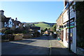
Midday New Year's Day 2019 photo of Church Street, Willingdon
This photo shows Church Street in Willingdon on a sunny New Year's Day at midday.
Image: © Adrian Diack
Taken: 1 Jan 2019
0.05 miles
9
Malthouse Cottages, Wish Hill
Grade II listed cottages near the centre of the village, the post office is around the corner to the left.
Image: © Simon Carey
Taken: 24 Jan 2009
0.05 miles
10
![Willingdon houses [17]](https://s1.geograph.org.uk/geophotos/07/19/81/7198189_241a210b_120x120.jpg)
Willingdon houses [17]
Wish House, number 115 Wish Hill, was formerly named Sea View. Built in the 18th century and constructed of stuccoed brick under a hipped tile roof. Listed, grade II, with details at: https://historicengland.org.uk/listing/the-list/list-entry/1043657
Once isolated villages, Upper Willingdon and Lower Willingdon, are now part of the built-up area of Eastbourne. Set on a spur at the foot of the South Downs, the village lies astride the A22 road, about 1 mile south of Polegate. There is evidence of occupation since the pre-Saxon age.
Image: © Michael Dibb
Taken: 10 May 2022
0.05 miles