IMAGES TAKEN NEAR TO
Parkway, EASTBOURNE, BN20 9DZ
Introduction
This page details the photographs taken nearby to Parkway, BN20 9DZ by members of the Geograph project.
The Geograph project started in 2005 with the aim of publishing, organising and preserving representative images for every square kilometre of Great Britain, Ireland and the Isle of Man.

There are currently over 7.5m images from over14,400 individuals and you can help contribute to the project by visiting https://www.geograph.org.uk
Image Map
Images are licensed for reuse under creativecommons.org/licenses/by-sa/2.0
Notes
- Clicking on the map will re-center to the selected point.
- The higher the marker number, the further away the image location is from the centre of the postcode.
Image Listing (22 Images Found)
Images are licensed for reuse under creativecommons.org/licenses/by-sa/2.0
Image
Details
Distance
1
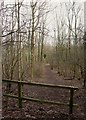
![Following the Jubilee Way in Eastbourne [2]](https://s1.geograph.org.uk/geophotos/07/19/45/7194505_d1a4af3b_120x120.jpg)
Following the Jubilee Way in Eastbourne [2]
The route is a broad track.
The Jubilee Way runs along the 300-foot contour of the wooded slopes of the South Downs escarpment overlooking Eastbourne. Some 6 miles long, the path runs from Willingdon through meadows and woodland to Eastbourne seafront. The path was named the Jubilee Way in 1977 in celebration of the Queen’s Silver Jubilee. Ash dieback disease has decimated the area.
Image: © Michael Dibb
Taken: 2 May 2022
0.05 miles
2
![Following the Jubilee Way in Eastbourne [3]](https://s2.geograph.org.uk/geophotos/07/19/45/7194506_5b786dc4_120x120.jpg)
Following the Jubilee Way in Eastbourne [3]
The track descends through the woods.
The Jubilee Way runs along the 300-foot contour of the wooded slopes of the South Downs escarpment overlooking Eastbourne. Some 6 miles long, the path runs from Willingdon through meadows and woodland to Eastbourne seafront. The path was named the Jubilee Way in 1977 in celebration of the Queen’s Silver Jubilee. Ash dieback disease has decimated the area.
Image: © Michael Dibb
Taken: 2 May 2022
0.06 miles
3
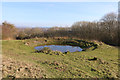
Midday Christmas 2018 view of the dew pond by Butts Lane
The photo shows a midday Christmas 2018 view of the dew pond on the slopes of the South Downs by Butts Lane.
Image: © Adrian Diack
Taken: 25 Dec 2018
0.09 miles
5
![Following the Jubilee Way in Eastbourne [1]](https://s0.geograph.org.uk/geophotos/07/19/45/7194504_d1d0fee4_120x120.jpg)
Following the Jubilee Way in Eastbourne [1]
From Melvill Lane this path leads to the woodland.
The Jubilee Way runs along the 300-foot contour of the wooded slopes of the South Downs escarpment overlooking Eastbourne. Some 6 miles long, the path runs from Willingdon through meadows and woodland to Eastbourne seafront. The path was named the Jubilee Way in 1977 in celebration of the Queen’s Silver Jubilee. Ash dieback disease has decimated the area.
Image: © Michael Dibb
Taken: 2 May 2022
0.11 miles
6
![Following the Jubilee Way in Eastbourne [5]](https://s0.geograph.org.uk/geophotos/07/19/45/7194508_bf6fbbb4_120x120.jpg)
Following the Jubilee Way in Eastbourne [5]
These steps take the route around the houses of Old Mansion Close.
The Jubilee Way runs along the 300-foot contour of the wooded slopes of the South Downs escarpment overlooking Eastbourne. Some 6 miles long, the path runs from Willingdon through meadows and woodland to Eastbourne seafront. The path was named the Jubilee Way in 1977 in celebration of the Queen’s Silver Jubilee. Ash dieback disease has decimated the area.
Image: © Michael Dibb
Taken: 2 May 2022
0.12 miles
7
![Following the Jubilee Way in Eastbourne [6]](https://s1.geograph.org.uk/geophotos/07/19/45/7194509_68610735_120x120.jpg)
Following the Jubilee Way in Eastbourne [6]
The path ascends away from the house of Old Mansion Close.
The Jubilee Way runs along the 300-foot contour of the wooded slopes of the South Downs escarpment overlooking Eastbourne. Some 6 miles long, the path runs from Willingdon through meadows and woodland to Eastbourne seafront. The path was named the Jubilee Way in 1977 in celebration of the Queen’s Silver Jubilee. Ash dieback disease has decimated the area.
Image: © Michael Dibb
Taken: 2 May 2022
0.13 miles
8
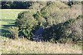
Eastward view of Butts Lane, Willingdon, East Sussex
Butts Lane is a steep, narrow and twisting road that gives access to and from the South Downs at Willingdon. The steep sides of the valley beside the road are often thickly wooded though many of the ash trees are dying due to ash dieback disease.
Image: © Andrew Diack
Taken: 21 Oct 2021
0.13 miles
9
Babylon Track
A footpath and bridleway that links Old Mansion Close in Ratton Village to Jevington via Willingdon Bottom and Butts Brow. The first section is a footpath until it joins a bridleway further up Babylon Down.
Image: © Simon Carey
Taken: 24 Jan 2009
0.17 miles
10
Ash dieback affecting woodland at Babylon Down, Eastbourne
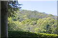
This photo shows the deadly outcome of ash dieback in woods at Babylon Down on the outskirts of Eastbourne. Although ash is the main tree in the woodland, other trees like sycamore and beech can give the misleading appearance that the woodland is healthy.
Image: © Andrew Diack
Taken: 24 Jun 2020
0.18 miles