IMAGES TAKEN NEAR TO
The Close, EASTBOURNE, BN20 9BW
Introduction
This page details the photographs taken nearby to The Close, BN20 9BW by members of the Geograph project.
The Geograph project started in 2005 with the aim of publishing, organising and preserving representative images for every square kilometre of Great Britain, Ireland and the Isle of Man.

There are currently over 7.5m images from over14,400 individuals and you can help contribute to the project by visiting https://www.geograph.org.uk
Image Map
Images are licensed for reuse under creativecommons.org/licenses/by-sa/2.0
Notes
- Clicking on the map will re-center to the selected point.
- The higher the marker number, the further away the image location is from the centre of the postcode.
Image Listing (16 Images Found)
Images are licensed for reuse under creativecommons.org/licenses/by-sa/2.0
Image
Details
Distance
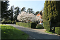
1
Flowering magnolia tree in Ratton, Eastbourne
This well established magnolia tree unfailingly gives a spectacular display of white to pink flowers every Spring.
Image: © Andrew Diack
Taken: 25 Mar 2022
0.01 miles
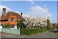
2
Spectacular flowering magnolia, The Close, Eastbourne
Behind the spectacular magnolia tree, in the centre of the photo, lies part of a line of yew trees, known as the Twelve Apostles. These trees were planted in the 15th century by the monks who lived in the nearby Benedictine Abbey. Reputedly a monk lies buried beneath each of the Twelve Apostles and that a curse linked to the trees means that anyone cutting one of them will soon die.
Image: © Andrew Diack
Taken: 25 Mar 2022
0.01 miles
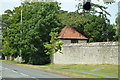
3
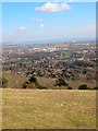
Ratton Village from Butts Brow
Looking east over Eastbourne and towards the cliffs at Hastings. Ratton Village is in the foreground.
Image: © Simon Carey
Taken: 4 Mar 2006
0.07 miles
4
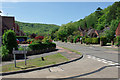
Babylon Way turns off Parkway
Babylon Way gets its name from Babylon Down, the wooded slope in the distance. The roads in this area have easy but steep access up through the woods to the top of the downs.
Image: © Robin Webster
Taken: 28 May 2010
0.12 miles
5
![Following the Jubilee Way in Eastbourne [7]](https://s2.geograph.org.uk/geophotos/07/19/45/7194510_218daafd_120x120.jpg)
Following the Jubilee Way in Eastbourne [7]
From an area that has been cleared of diseased trees, Eastbourne and the coast is seen over the rooftops of the houses of Old Mansion Close.
The Jubilee Way runs along the 300-foot contour of the wooded slopes of the South Downs escarpment overlooking Eastbourne. Some 6 miles long, the path runs from Willingdon through meadows and woodland to Eastbourne seafront. The path was named the Jubilee Way in 1977 in celebration of the Queen’s Silver Jubilee. Ash dieback disease has decimated the area.
Image: © Michael Dibb
Taken: 2 May 2022
0.13 miles
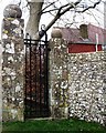
7
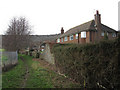
Bridleway to Bourne Hill
Separating Willingdon Golf Course beyond the fence to the left and Ratton Village beyond the walls to the right. The latter was built on the site of Ratton Manor some of whose boundary walls still survive. The bridleway begins on Willingdon Road, the A2270, and joins the South Downs Way on Bourne Hill.
Image: © Simon Carey
Taken: 24 Jan 2009
0.15 miles
8
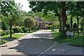
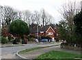
Walnut Tree Walk - private road
A case of a "Walk" with no separate provision for walkers.
Image: © Robin Webster
Taken: 28 May 2010
0.16 miles