IMAGES TAKEN NEAR TO
Upper Kings Drive, EASTBOURNE, BN20 9AP
Introduction
This page details the photographs taken nearby to Upper Kings Drive, BN20 9AP by members of the Geograph project.
The Geograph project started in 2005 with the aim of publishing, organising and preserving representative images for every square kilometre of Great Britain, Ireland and the Isle of Man.

There are currently over 7.5m images from over14,400 individuals and you can help contribute to the project by visiting https://www.geograph.org.uk
Image Map
Images are licensed for reuse under creativecommons.org/licenses/by-sa/2.0
Notes
- Clicking on the map will re-center to the selected point.
- The higher the marker number, the further away the image location is from the centre of the postcode.
Image Listing (148 Images Found)
Images are licensed for reuse under creativecommons.org/licenses/by-sa/2.0
Image
Details
Distance
1
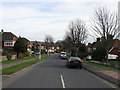
Upper Kings Drive
The road exists on a 1920s OS map though it has no buildings along it. It links the Willingdon Roundabout with Wish Hill.
Image: © Simon Carey
Taken: 24 Jan 2009
0.00 miles
2
![Willingdon houses [15]](https://s0.geograph.org.uk/geophotos/07/19/81/7198164_17171202_120x120.jpg)
Willingdon houses [15]
Stream Cottage, number 65 Wish Hill, was probably built in the early to mid 19th century. Constructed of cobbles with brick quoins and dressings, partly rendered and painted, all under a tile roof. Listed, grade II, with details at: https://historicengland.org.uk/listing/the-list/list-entry/1043658
Once isolated villages, Upper Willingdon and Lower Willingdon, are now part of the built-up area of Eastbourne. Set on a spur at the foot of the South Downs, the village lies astride the A22 road, about 1 mile south of Polegate. There is evidence of occupation since the pre-Saxon age.
Image: © Michael Dibb
Taken: 10 May 2022
0.07 miles
3
![Willingdon houses [13]](https://s3.geograph.org.uk/geophotos/07/19/81/7198151_07f51bf0_120x120.jpg)
Willingdon houses [13]
Numbers 67 and 69 Upper King's Drive are two cottages, probably built in the 18th century. Constructed of flint and brick with brick quoins and dressings under a hipped tile roof. Listed, grade II, with details at: https://historicengland.org.uk/listing/the-list/list-entry/1353106
Once isolated villages, Upper Willingdon and Lower Willingdon, are now part of the built-up area of Eastbourne. Set on a spur at the foot of the South Downs, the village lies astride the A22 road, about 1 mile south of Polegate. There is evidence of occupation since the pre-Saxon age.
Image: © Michael Dibb
Taken: 10 May 2022
0.07 miles
4
![Willingdon houses [14]](https://s3.geograph.org.uk/geophotos/07/19/81/7198159_8968faab_120x120.jpg)
Willingdon houses [14]
The Cottage, Old Barn Lane, was formerly named Malthouse Cottage. Probably built in the 17th century with later additions and alterations. 'L' shaped, constructed of rubble stone, partly rendered and partly weatherboarded, all under a tile roof. Listed, grade II, with details at: https://historicengland.org.uk/listing/the-list/list-entry/1190677
Once isolated villages, Upper Willingdon and Lower Willingdon, are now part of the built-up area of Eastbourne. Set on a spur at the foot of the South Downs, the village lies astride the A22 road, about 1 mile south of Polegate. There is evidence of occupation since the pre-Saxon age.
Image: © Michael Dibb
Taken: 10 May 2022
0.09 miles
5
![Willingdon houses [16]](https://s3.geograph.org.uk/geophotos/07/19/81/7198167_a8b2a8b8_120x120.jpg)
Willingdon houses [16]
Odd numbers 91 to 97 Wish Hill are a terrace of 4 houses. Probably built in the mid 19th century. Constructed of knapped flint with brick quoins and dressings under a hipped tile roof. Listed, grade II, with details at: https://historicengland.org.uk/listing/the-list/list-entry/1190664
Once isolated villages, Upper Willingdon and Lower Willingdon, are now part of the built-up area of Eastbourne. Set on a spur at the foot of the South Downs, the village lies astride the A22 road, about 1 mile south of Polegate. There is evidence of occupation since the pre-Saxon age.
Image: © Michael Dibb
Taken: 10 May 2022
0.09 miles
6
![Willingdon features [2]](https://s1.geograph.org.uk/geophotos/07/19/81/7198197_96861b28_120x120.jpg)
Willingdon features [2]
Outside the post office in Wish Hill Image is this K6 telephone box, designed in 1935 by Sir Giles Gilbert Scott. Listed, grade II, with details at: https://historicengland.org.uk/listing/the-list/list-entry/1393285
Once isolated villages, Upper Willingdon and Lower Willingdon, are now part of the built-up area of Eastbourne. Set on a spur at the foot of the South Downs, the village lies astride the A22 road, about 1 mile south of Polegate. There is evidence of occupation since the pre-Saxon age.
Image: © Michael Dibb
Taken: 10 May 2022
0.10 miles
7
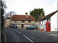
Willingdon Post Office, Wish Hill
The building is very old dating back to the 16th century though it only became a post office in 1940 and continued until falling victim to the cuts of 2008. However, the shop is still open and remains a focal point for the local village that has seen virtually all other services disappear into nearby Eastbourne. Next to the post office is Pelham Cottage and beyond is Malthouse Cottages occupied by a solicitor.
Image: © Simon Carey
Taken: 24 Jan 2009
0.10 miles
8
![Willingdon buildings [6]](https://s1.geograph.org.uk/geophotos/07/19/81/7198193_ec5df950_120x120.jpg)
Willingdon buildings [6]
The Post Office, number 116 Wish Hill, was probably built in the early 19th century. In two parallel ranges, the front range of flint with brick quoins, the rear range of brick, the whole painted white, all under a tile roof. Listed, grade II, with details at: https://historicengland.org.uk/listing/the-list/list-entry/1353107 Seen here in context is the K6 telephone box seen in detail at Image
Once isolated villages, Upper Willingdon and Lower Willingdon, are now part of the built-up area of Eastbourne. Set on a spur at the foot of the South Downs, the village lies astride the A22 road, about 1 mile south of Polegate. There is evidence of occupation since the pre-Saxon age.
Image: © Michael Dibb
Taken: 10 May 2022
0.10 miles
9
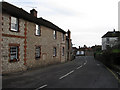
Malthouse Cottages, Wish Hill
Grade II listed cottages near the centre of the village, the post office is around the corner to the left.
Image: © Simon Carey
Taken: 24 Jan 2009
0.10 miles
10
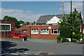
Home of the Beachy Head chaplaincy team
So says the small sign, but not very close to Beachy Head - does it make a difference?
Image: © Robin Webster
Taken: 28 May 2010
0.10 miles