IMAGES TAKEN NEAR TO
Willingdon Road, EASTBOURNE, BN20 9AH
Introduction
This page details the photographs taken nearby to Willingdon Road, BN20 9AH by members of the Geograph project.
The Geograph project started in 2005 with the aim of publishing, organising and preserving representative images for every square kilometre of Great Britain, Ireland and the Isle of Man.

There are currently over 7.5m images from over14,400 individuals and you can help contribute to the project by visiting https://www.geograph.org.uk
Image Map
Images are licensed for reuse under creativecommons.org/licenses/by-sa/2.0
Notes
- Clicking on the map will re-center to the selected point.
- The higher the marker number, the further away the image location is from the centre of the postcode.
Image Listing (27 Images Found)
Images are licensed for reuse under creativecommons.org/licenses/by-sa/2.0
Image
Details
Distance
3
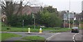
Walnut Tree Walk - private road
A case of a "Walk" with no separate provision for walkers.
Image: © Robin Webster
Taken: 28 May 2010
0.05 miles
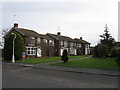
5
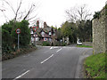
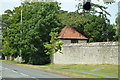
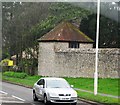
Entrance to Ratton Manor Estate
The former gate to Ratton Manor still acts as the entrance to the estate built on it with the former lodge to the left. Park Lane itself was part of the estate linking the manor with parklands on what is modern day Hampden Park. The road it crosses is the A2270, Willingdon Road.
Image: © Simon Carey
Taken: 24 Jan 2009
0.07 miles
8
![Following the Jubilee Way in Eastbourne [7]](https://s2.geograph.org.uk/geophotos/07/19/45/7194510_218daafd_120x120.jpg)
Following the Jubilee Way in Eastbourne [7]
From an area that has been cleared of diseased trees, Eastbourne and the coast is seen over the rooftops of the houses of Old Mansion Close.
The Jubilee Way runs along the 300-foot contour of the wooded slopes of the South Downs escarpment overlooking Eastbourne. Some 6 miles long, the path runs from Willingdon through meadows and woodland to Eastbourne seafront. The path was named the Jubilee Way in 1977 in celebration of the Queen’s Silver Jubilee. Ash dieback disease has decimated the area.
Image: © Michael Dibb
Taken: 2 May 2022
0.12 miles
10
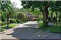
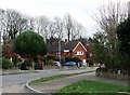
Park Lane
Modern houses formed in a square around a small green between the lane and Ratton School.
Image: © Simon Carey
Taken: 24 Jan 2009
0.12 miles