IMAGES TAKEN NEAR TO
Bracken Road, EASTBOURNE, BN20 8SJ
Introduction
This page details the photographs taken nearby to Bracken Road, BN20 8SJ by members of the Geograph project.
The Geograph project started in 2005 with the aim of publishing, organising and preserving representative images for every square kilometre of Great Britain, Ireland and the Isle of Man.

There are currently over 7.5m images from over14,400 individuals and you can help contribute to the project by visiting https://www.geograph.org.uk
Image Map
Images are licensed for reuse under creativecommons.org/licenses/by-sa/2.0
Notes
- Clicking on the map will re-center to the selected point.
- The higher the marker number, the further away the image location is from the centre of the postcode.
Image Listing (54 Images Found)
Images are licensed for reuse under creativecommons.org/licenses/by-sa/2.0
Image
Details
Distance
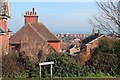
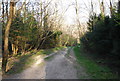
1
Priory Heights
Edge of a housing estate to the west of Downside area. Further Plantation woods are seen ahead.
Image: © Oast House Archive
Taken: 19 May 2011
0.05 miles
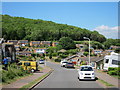
2
![Following the Jubilee Way in Eastbourne [20]](https://s0.geograph.org.uk/geophotos/07/19/45/7194528_6ea5751e_120x120.jpg)
Following the Jubilee Way in Eastbourne [20]
Hill Road, seen from the path.
The Jubilee Way runs along the 300-foot contour of the wooded slopes of the South Downs escarpment overlooking Eastbourne. Some 6 miles long, the path runs from Willingdon through meadows and woodland to Eastbourne seafront. The path was named the Jubilee Way in 1977 in celebration of the Queen’s Silver Jubilee. Ash dieback disease has decimated the area.
Image: © Michael Dibb
Taken: 2 May 2022
0.06 miles
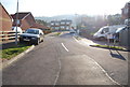
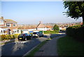
3
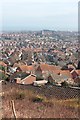
North Avenue
Looking from Foxhole Brow, across roofs of houses on Hill Road and Whitehill Close.
Image: © Oast House Archive
Taken: 23 Feb 2012
0.07 miles
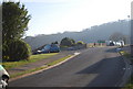
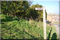
9
![Following the Jubilee Way in Eastbourne [19]](https://s1.geograph.org.uk/geophotos/07/19/45/7194525_0fc3ca19_120x120.jpg)
Following the Jubilee Way in Eastbourne [19]
The path now runs alongside the rear garden fences of the houses of Hill Road.
The Jubilee Way runs along the 300-foot contour of the wooded slopes of the South Downs escarpment overlooking Eastbourne. Some 6 miles long, the path runs from Willingdon through meadows and woodland to Eastbourne seafront. The path was named the Jubilee Way in 1977 in celebration of the Queen’s Silver Jubilee. Ash dieback disease has decimated the area.
Image: © Michael Dibb
Taken: 2 May 2022
0.10 miles