IMAGES TAKEN NEAR TO
Victoria Road, EASTBOURNE, BN20 8NP
Introduction
This page details the photographs taken nearby to Victoria Road, BN20 8NP by members of the Geograph project.
The Geograph project started in 2005 with the aim of publishing, organising and preserving representative images for every square kilometre of Great Britain, Ireland and the Isle of Man.

There are currently over 7.5m images from over14,400 individuals and you can help contribute to the project by visiting https://www.geograph.org.uk
Image Map
Images are licensed for reuse under creativecommons.org/licenses/by-sa/2.0
Notes
- Clicking on the map will re-center to the selected point.
- The higher the marker number, the further away the image location is from the centre of the postcode.
Image Listing (67 Images Found)
Images are licensed for reuse under creativecommons.org/licenses/by-sa/2.0
Image
Details
Distance
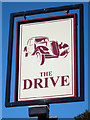
3
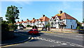
The Former Drive Public House, Victoria Drive, Eastbourne
There is local opposition to Sainsbury's converting this into a Supermarket: http://www.eastbourneherald.co.uk/news/local/concerns-grow-over-old-town-superstore-1-5167861
Image: © PAUL FARMER
Taken: 2 Nov 2013
0.09 miles
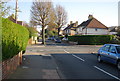
4
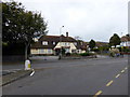
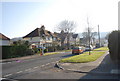
Beechy Avenue and Victoria Drive
Suburban road junction in Downside, Eastbourne.
Image: © Jonathan Billinger
Taken: 6 Jul 2015
0.09 miles
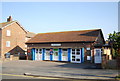
6
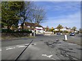
Victoria Drive
The Sainsbury's Local store was previously a pub called The Drive Image
Image: © Gerald England
Taken: 27 Apr 2017
0.09 miles