IMAGES TAKEN NEAR TO
East Dean Road, EASTBOURNE, BN20 0LH
Introduction
This page details the photographs taken nearby to East Dean Road, BN20 0LH by members of the Geograph project.
The Geograph project started in 2005 with the aim of publishing, organising and preserving representative images for every square kilometre of Great Britain, Ireland and the Isle of Man.

There are currently over 7.5m images from over14,400 individuals and you can help contribute to the project by visiting https://www.geograph.org.uk
Image Map
Images are licensed for reuse under creativecommons.org/licenses/by-sa/2.0
Notes
- Clicking on the map will re-center to the selected point.
- The higher the marker number, the further away the image location is from the centre of the postcode.
Image Listing (16 Images Found)
Images are licensed for reuse under creativecommons.org/licenses/by-sa/2.0
Image
Details
Distance
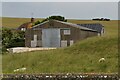
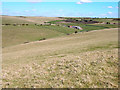
2
Ringwood
Consisting of two cottages and three barns of varying ages. Farming first occurred here during the first decade of the 19th century when the flint walls of the surrounding fields were built. The main house was known as Peakdown House on Eastbourne's 1841 tithe map, Halfway House on the OS map of 1875, then Ringwood on the 1899 map. The flint barn adjacent to the cottages dates from the early 19th century but the other two are fairly recent. Beyond is the southern portion of Crunden's Bottom which was once farmed from here but is now part of Eastbourne Downs Golf Course.
Image: © Simon Carey
Taken: 26 Dec 2013
0.02 miles
3
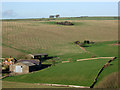
East Field
The name of the field according to Eastbourne's 1841 tithe map that lies to the immediate east of Image The walls date from the first decade of the 19th century along with the adjacent flint barn when a farm was first built here.
Image: © Simon Carey
Taken: 26 Dec 2013
0.03 miles
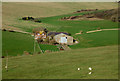
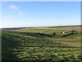
5
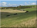
Downland near Eastbourne
A view of Ringwood Bottom and Ringwood Farm with Eastbourne Downs Golf Club above.
Image: © Andrew Smith
Taken: 23 Aug 2008
0.13 miles
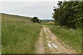
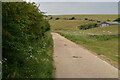
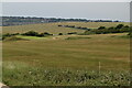
7
Ringwood Bottom
Looking north east from the footpath that links the A259 with the bridleway that runs the length of this dip. Eastbourne Downs Golf Club can be seen in the distance.
Image: © Simon Carey
Taken: 5 Apr 2006
0.17 miles
8
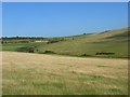
Downland near Eastbourne
A view up Ringwood Bottom to the green grass of the Eastbourne Downs Golf Club.
Image: © Andrew Smith
Taken: 23 Aug 2008
0.17 miles
10
Ringwood Bottom
The eastern end of the dry valley that runs westwards to East Dean just visible in the distance. To the right is Image
Image: © Simon Carey
Taken: 26 Dec 2013
0.20 miles