IMAGES TAKEN NEAR TO
Deneside, EASTBOURNE, BN20 0HX
Introduction
This page details the photographs taken nearby to Deneside, BN20 0HX by members of the Geograph project.
The Geograph project started in 2005 with the aim of publishing, organising and preserving representative images for every square kilometre of Great Britain, Ireland and the Isle of Man.

There are currently over 7.5m images from over14,400 individuals and you can help contribute to the project by visiting https://www.geograph.org.uk
Image Map
Images are licensed for reuse under creativecommons.org/licenses/by-sa/2.0
Notes
- Clicking on the map will re-center to the selected point.
- The higher the marker number, the further away the image location is from the centre of the postcode.
Image Listing (74 Images Found)
Images are licensed for reuse under creativecommons.org/licenses/by-sa/2.0
Image
Details
Distance
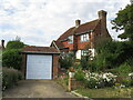
1
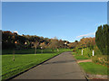
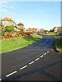
Deneside, East Dean
Residential road that is part of the Downlands estate that was developed from the 1930s onwards. The road itself splits and loops around the large green in the middle. Deneside lies within a combe called Peak Dean and the field within it was known as Peakdean Laine according to East Dean's 1844 tithe map.
Image: © Simon Carey
Taken: 23 Nov 2013
0.06 miles
2
Dene Close, East Dean
Small cul de sac off Michel Dene Road that was developed after the Second World War.
Image: © Simon Carey
Taken: 26 Dec 2013
0.09 miles
3
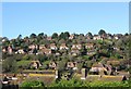
Downlands Estate, East Dean
Much of the village north of the A259 is a private estate that began to develop during the 1920s but was not completed until the 1970s. This view is taken from the A259 at the junction of Cophall Lane and looks towards the roofscapes in the foreground based around Wnethill Close and Sussex Gardens, then beyond rises a little to those houses that straddle Michel Dene Road, followed by another row that line Hillside, and are completed on the peak by those based in Warren Lane.
Image: © Simon Carey
Taken: 26 Dec 2013
0.09 miles
4
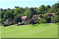
Dene Side, East Dean
Relatively modern houses are arranged around a green. Above are ones on Warren Lane.
Image: © Andrew Smith
Taken: 23 Aug 2008
0.10 miles
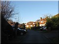
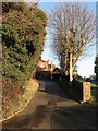
5
House on Micheldene Lane
Part of the Downland Estate which consumed a large slice of downland for housing in the post-war years.
Image: © David M Clark
Taken: 18 Jul 2023
0.12 miles
6
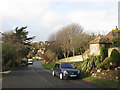
Michel Dene Road, East Dean
Looking westwards towards the junction with Deneside in the distance.
Image: © Simon Carey
Taken: 14 Dec 2013
0.12 miles
7
Went Lane, East Dean
Small cul de sac off Dene Close that was developed after the Second World War.
Image: © Simon Carey
Taken: 26 Dec 2013
0.12 miles
8
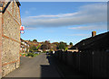
Downlands Way, East Dean
The only access road for Image The houses date from the 1970s.
Image: © Simon Carey
Taken: 23 Nov 2013
0.13 miles
9
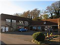
Barn Stores and Post Office, East Dean
The former barns and stables of Gore Farm have been converted into a small shopping area, through the walkway next to Barn Stores are a vet and hairdressers. The Post Office moved here from Lower Street in 2008 which means the main village shops are concentrated in an area north of the A259 where most of the population now reside. South of the main road in the old part of the village those shops that still exist are now geared towards the tourist trade.
Image: © Simon Carey
Taken: 23 Nov 2013
0.14 miles
10
Michel Dene Road, East Dean
Viewed from the junction with Elven Lane and looking northwards towards the junction with Summerdown Lane. Michel Dene Road snakes northwards from the A259 and was developed in stages with this part built in the post Second World War years.
Image: © Simon Carey
Taken: 14 Dec 2013
0.15 miles