IMAGES TAKEN NEAR TO
Hillside, EASTBOURNE, BN20 0HE
Introduction
This page details the photographs taken nearby to Hillside, BN20 0HE by members of the Geograph project.
The Geograph project started in 2005 with the aim of publishing, organising and preserving representative images for every square kilometre of Great Britain, Ireland and the Isle of Man.

There are currently over 7.5m images from over14,400 individuals and you can help contribute to the project by visiting https://www.geograph.org.uk
Image Map
Images are licensed for reuse under creativecommons.org/licenses/by-sa/2.0
Notes
- Clicking on the map will re-center to the selected point.
- The higher the marker number, the further away the image location is from the centre of the postcode.
Image Listing (169 Images Found)
Images are licensed for reuse under creativecommons.org/licenses/by-sa/2.0
Image
Details
Distance
1
Downlands Estate, East Dean
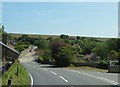
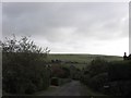
Much of the village north of the A259 is a private estate that began to develop during the 1920s but was not completed until the 1970s. This view is taken from the A259 at the junction of Cophall Lane and looks towards the roofscapes in the foreground based around Wnethill Close and Sussex Gardens, then beyond rises a little to those houses that straddle Michel Dene Road, followed by another row that line Hillside, and are completed on the peak by those based in Warren Lane.
Image: © Simon Carey
Taken: 26 Dec 2013
0.05 miles
2
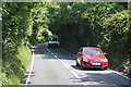
Forge Cottage, Friston Hill, East Dean
Located opposite the junction with Upper Street and dating back to at least the 18th century possibly earlier. As the name suggests it was the former village forge.
Image: © Simon Carey
Taken: 26 Dec 2013
0.11 miles
3
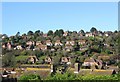
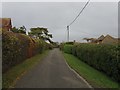
Hillside, East Dean
A residential road part of the Downlands estate that was originally laid out in the late 1920s and developed intermittently up to the Second World War and completed after. The road heads east from Warren Lane then turns north and follows the slope down to Deneside. The hill beyond is Mill Down.
Image: © Simon Carey
Taken: 30 Nov 2013
0.11 miles
4
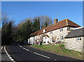
Warren Lane, East Dean
Viewed from the southern end of the lane that heads northwards along the eastern brow of the hill and joins The Ridgeway at the junction with The Brow. The road was laid out in the late 1920s and developed intermittently before the Second World War. Beyond the hedge on the right is the junction with Image whilst further up to the left is another with Windmill Lane.
Image: © Simon Carey
Taken: 30 Nov 2013
0.11 miles
6
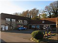
Barn Stores and Post Office, East Dean
The former barns and stables of Gore Farm have been converted into a small shopping area, through the walkway next to Barn Stores are a vet and hairdressers. The Post Office moved here from Lower Street in 2008 which means the main village shops are concentrated in an area north of the A259 where most of the population now reside. South of the main road in the old part of the village those shops that still exist are now geared towards the tourist trade.
Image: © Simon Carey
Taken: 23 Nov 2013
0.12 miles
7
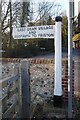
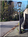
Old Direction Sign - Signpost by the A259, Eastbourne Road
Black iron cap finial - 1 arm; East Sussex wood by the A259, in parish of East Dean and Friston (Wealden District), Eastbourne Road junction with Upper Street, on verge behind wall at junction.
Surveyed
Milestone Society National ID: SX_TV5597C
Image: © Milestone Society
Taken: Unknown
0.12 miles