IMAGES TAKEN NEAR TO
Friston Downs, EASTBOURNE, BN20 0ET
Introduction
This page details the photographs taken nearby to Friston Downs, BN20 0ET by members of the Geograph project.
The Geograph project started in 2005 with the aim of publishing, organising and preserving representative images for every square kilometre of Great Britain, Ireland and the Isle of Man.

There are currently over 7.5m images from over14,400 individuals and you can help contribute to the project by visiting https://www.geograph.org.uk
Image Map
Images are licensed for reuse under creativecommons.org/licenses/by-sa/2.0
Notes
- Clicking on the map will re-center to the selected point.
- The higher the marker number, the further away the image location is from the centre of the postcode.
Image Listing (32 Images Found)
Images are licensed for reuse under creativecommons.org/licenses/by-sa/2.0
Image
Details
Distance
1
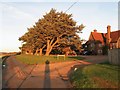
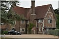
Friston Down, Old Willingdon Road, Friston
A mock tudor mansion built on the old Friston-Willingdon road sometime between the wars catching the last sun of the day.
Image: © Simon Carey
Taken: 23 Nov 2013
0.06 miles
2
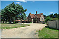
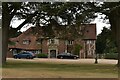
Friston Down (house)
Unusually along this lane, the frontage is completely open. Is this just a private house?
Image: © Robin Webster
Taken: 15 Jun 2010
0.07 miles
4
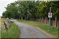
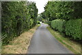
Roadside trees on Old Willingdon Road Friston
Image: © Dave Spicer
Taken: 19 Jul 2012
0.08 miles
6
Swallows, Old Willingdon Road, Friston
Large house built on a former field called Little Pasture during the early 1930s in the style of a Wealden farmhouse. The current residential layout of Friston and East Dean owes much to the break up of the Peakdean Estate in the late 1920s. The smaller bungalow to the left is Swallows Cottage.
Image: © Simon Carey
Taken: 23 Nov 2013
0.10 miles
10
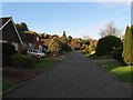
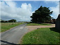
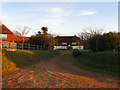
Peakdean Lane, East Dean
A cul de sac that runs from Deneside up to the end of the combe once known as Peak Dean. The road was constructed in two parts, the southern portion was developed after the Second world War and stopped at this point where Peakdean Farm had once existed. The farm was the only building on the Downs on the 1844 tithe map and survived until the 1970s when it was demolished and the northern part of the lane was developed. The houses in view to the left mark the site of the former farm buildings.
Image: © Simon Carey
Taken: 23 Nov 2013
0.15 miles