IMAGES TAKEN NEAR TO
Eastbourne Road, EASTBOURNE, BN20 0BL
Introduction
This page details the photographs taken nearby to Eastbourne Road, BN20 0BL by members of the Geograph project.
The Geograph project started in 2005 with the aim of publishing, organising and preserving representative images for every square kilometre of Great Britain, Ireland and the Isle of Man.

There are currently over 7.5m images from over14,400 individuals and you can help contribute to the project by visiting https://www.geograph.org.uk
Image Map
Images are licensed for reuse under creativecommons.org/licenses/by-sa/2.0
Notes
- Clicking on the map will re-center to the selected point.
- The higher the marker number, the further away the image location is from the centre of the postcode.
Image Listing (335 Images Found)
Images are licensed for reuse under creativecommons.org/licenses/by-sa/2.0
Image
Details
Distance
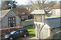
1
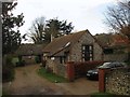
The Old Village Hall, Eastbourne Road, East Dean
Originally a cottage that was converted into a hall until 2000 when Image was opened and the building reverted to being a dwelling. Beyond is Flint Cottage that was once a farm outbuilding that has now been converted into a residence. See also Image which is obscured by The Old Village Hall.
Image: © Simon Carey
Taken: 14 Dec 2013
0.00 miles

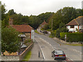
3
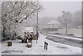
A259 Eastbourne Road towards Friston Hill, East Dean, East Sussex
Micheldene Road is on the right just beyond the white fence which hides a new development which is being built on the site of a petrol station and garage.
Image: © Kevin Gordon
Taken: 6 Apr 2008
0.01 miles
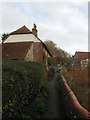
4
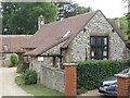
Old Village Hall
Converted to residential use when the new and larger hall was built next to the village car park.
Image: © David M Clark
Taken: 18 Jul 2023
0.01 miles
5
Garden Cottage, Eastbourne Road, East Dean
Viewed from Gilberts Drive and built after the Second World War on the site of a former market garden belonging to Gore Farm. Beyond is Image
Image: © Simon Carey
Taken: 26 Dec 2013
0.01 miles
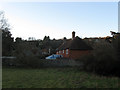
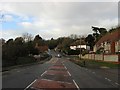
7
East Dean
Eastbourne Road (A259) passing through the village of East Dean.
Image: © David Dixon
Taken: 5 Aug 2012
0.02 miles
8
Cottages, Eastbourne Road, East Dean
Two 18th century flint cottages lying at right angles to the A259 on a path that heads south to the village green. Went Hill Cottage is the nearest whilst Gore Cottage is beyond.
Image: © Simon Carey
Taken: 14 Dec 2013
0.02 miles
9
Eastbourne Road, East Dean
The main A259 as it heads through the village of East Dean. The road drops down from Friston before climbing up Eastdean Down as it heads to Eastbourne. To the left are Image whilst on the immediate right is Image built on the site of a garage that was previously part of the grounds of Gore Farm. Then comes the junction with Michel Dene Road, Beech Tree Cottage and as you head up the slope, Forge Cottage
Image: © Simon Carey
Taken: 14 Dec 2013
0.02 miles
10
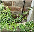
OS benchmark, Friston Hill, East Dean
Cut mark on wall of private dwelling.
Image: © Dave Alston
Taken: 23 Jun 2024
0.02 miles