IMAGES TAKEN NEAR TO
Station Approach, BRIGHTON, BN1 9SD
Introduction
This page details the photographs taken nearby to Station Approach, BN1 9SD by members of the Geograph project.
The Geograph project started in 2005 with the aim of publishing, organising and preserving representative images for every square kilometre of Great Britain, Ireland and the Isle of Man.

There are currently over 7.5m images from over14,400 individuals and you can help contribute to the project by visiting https://www.geograph.org.uk
Image Map
Images are licensed for reuse under creativecommons.org/licenses/by-sa/2.0
Notes
- Clicking on the map will re-center to the selected point.
- The higher the marker number, the further away the image location is from the centre of the postcode.
Image Listing (285 Images Found)
Images are licensed for reuse under creativecommons.org/licenses/by-sa/2.0
Image
Details
Distance
1

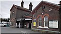
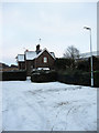
Station Approach
The view immediately to the north of Image The two cottages to the left are privately owned whereas Howard House to the right is the Roman Catholic chaplaincy to both the universities of Sussex and Brighton. The other side of the buildings back on to the A27 trunk road.
Image: © Simon Carey
Taken: 8 Aug 2007
0.01 miles
2
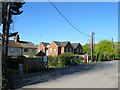
Station Approach, Falmer
The buildings on the left were originally known as Railway Cottages and were built in stages during the 20th century; those on the left were post Second World War Two but are now just numbered 3-5. On the right the former numbers 1 and 2 were built after the First World War but have been extended and renamed Howard House which is home to the Catholic chaplain of the University of Sussex.
Image: © Simon Carey
Taken: 16 Apr 2014
0.01 miles
3
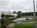
A27 underpass at Falmer
Heading north from Falmer Station and the Amex Station to the University of Sussex
Image: © Paul Gillett
Taken: 1 Sep 2014
0.03 miles
5

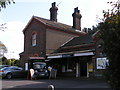
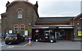
Falmer Station
The line from Brighton to Lewes was built in 1846 and the original station lay to the east of the village. A bit of arm twisting by the Pelhams at nearby Stanmer House meant the station was moved to this position in 1865 no nearer to the village than before but much nearer the big country house. For many years a sleepy station its traffic was increased by the building of the nearby University of Sussex in the early 1990s and has continued to do so as that campus has expanded and another built that was initially the Brighton College of Education and is now the University of Brighton. It will be further used by those visiting the new football stadium from the beginning of next season.
Image: © Simon Carey
Taken: 18 Dec 2010
0.03 miles
6
Cottages, Station Approach
With Falmer being a former estate village these cottages are numbered 41-42, with 43 being located in Middle Street next to the Swan public house. Most likely built with the station in 1865.
Image: © Simon Carey
Taken: 18 Dec 2010
0.03 miles
8

A27 Westbound Carriageway
Taken from the corner of Station Approach with a rare break in the traffic.
Image: © Simon Carey
Taken: 8 Aug 2007
0.03 miles
9
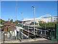
Falmer Station
Viewed from the widened footbridge constructed in 2010 on the site of the old goods yard. This is the second station built to serve the village, the original lay on the eastern side of the village and was used between 1848 and 1865 until it was rested to the current location in no small part due to convenience of the Pelham family who then resided in nearby Stanmer House. Traffic remained at sleepy country station pace until the 1960s when the University of Sussex and later Brighton Polytechnic built campuses nearby increasing passenger traffic greatly. The station has also served the American Express Community Stadium since 2010 and is due to have its platform lengthened to deal with the large crowds.
Image: © Simon Carey
Taken: 16 Apr 2014
0.04 miles