IMAGES TAKEN NEAR TO
Lewes Road, BRIGHTON, BN1 9PW
Introduction
This page details the photographs taken nearby to Lewes Road, BN1 9PW by members of the Geograph project.
The Geograph project started in 2005 with the aim of publishing, organising and preserving representative images for every square kilometre of Great Britain, Ireland and the Isle of Man.

There are currently over 7.5m images from over14,400 individuals and you can help contribute to the project by visiting https://www.geograph.org.uk
Image Map
Images are licensed for reuse under creativecommons.org/licenses/by-sa/2.0
Notes
- Clicking on the map will re-center to the selected point.
- The higher the marker number, the further away the image location is from the centre of the postcode.
Image Listing (33 Images Found)
Images are licensed for reuse under creativecommons.org/licenses/by-sa/2.0
Image
Details
Distance
1
Brian Aldridge Community Academy
Known locally by its acronym BACA, the current school opened in 2010 replacing the previous failing Falmer High School. The school had originally opened as Stanmer Secondary School in 1955 and was also known as Westlain for a while. The current building was opened in 2011 with the original structure demolished and now used as Image whilst awaiting planning permission for a new student hall of residence and multi-storey car park. The wood beyond is Westlain Belt which once provided the southern boundary of a field called Short Hawth according to Falmer's 1840 tithe map.
Image: © Simon Carey
Taken: 19 Apr 2014
0.04 miles
2

Path, Westlain Belt
A well used one which seems to go nowhere.
Image: © Simon Carey
Taken: 9 Mar 2014
0.07 miles
3
Brighton Health & Racquets Club
Owned by Virgin Active and located between the University of Brighton's Falmer campus and Image The club opened during the late 1990s and contains three indoor pools and ten indoor tennis courts amongst a number of other facilities.
Image: © Simon Carey
Taken: 19 Apr 2014
0.11 miles
4
Virgin Active, Falmer
Website: https://www.virginactive.co.uk/clubs/brighton
Image: © Paul Gillett
Taken: 5 Aug 2018
0.11 miles
5
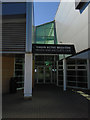
The Bridge Community Education Centre
Temporary building housing an adult community and education centre which was once located in the old Falmer School which occupied the site until its recent demolition. Richmond Hill is beyond containing the wood known as Russell's Clump.
Image: © Simon Carey
Taken: 9 Mar 2014
0.12 miles
6
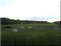
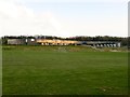
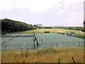
Falmer Sports Centre, University of Brighton
The outdoor facilities of the sports centre which include both artificial and grass sports pitches. The sports ground has been laid out on a former field whose wooded boundaries are still clearly seen and was called Great Wilkins according to Falmer's 1840 tithe map. The name has been commemorated by Image which lies to the north of the sports field. See also Image
Image: © Simon Carey
Taken: 19 Apr 2014
0.12 miles
7
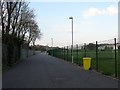
Walkway to the University of Brighton
Linking Lucraft Road to the university's Falmer campus and American Express Community Stadium. The playing field to the right belongs to Image
Image: © Simon Carey
Taken: 19 Apr 2014
0.14 miles
8
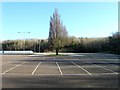
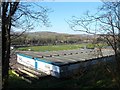
The Bridge Car Park
The car park is located on the old site of Falmer School which opened here in the 1950s and was known as Stanmer as well as Westlain in its time. The buildings were demolished three years ago after the school moved to a new build out of shot to the left. At the far end of the car park is Image and Image though this view will not remain for too long as planning permission has been given to build a combined student residence and multi-storey car park for the nearby football ground.
Image: © Simon Carey
Taken: 9 Mar 2014
0.15 miles
9
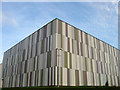
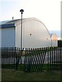
Falmer Sports Centre, University of Brighton
Completed in October 2010 and housing indoor tennis and netball courts.
Image: © Simon Carey
Taken: 23 Sep 2011
0.15 miles
10
Sports Grounds, University of Brighton
Near to the Falmer Campus
Image: © Paul Gillett
Taken: 6 Jul 2013
0.16 miles