IMAGES TAKEN NEAR TO
Newick Road, BRIGHTON, BN1 9JU
Introduction
This page details the photographs taken nearby to Newick Road, BN1 9JU by members of the Geograph project.
The Geograph project started in 2005 with the aim of publishing, organising and preserving representative images for every square kilometre of Great Britain, Ireland and the Isle of Man.

There are currently over 7.5m images from over14,400 individuals and you can help contribute to the project by visiting https://www.geograph.org.uk
Image Map
Images are licensed for reuse under creativecommons.org/licenses/by-sa/2.0
Notes
- Clicking on the map will re-center to the selected point.
- The higher the marker number, the further away the image location is from the centre of the postcode.
Image Listing (19 Images Found)
Images are licensed for reuse under creativecommons.org/licenses/by-sa/2.0
Image
Details
Distance
3
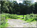
Footpath in Coldean Wood
An area of access woodland to the east of Coldean Lane.
Image: © Dave Spicer
Taken: 22 Jul 2012
0.11 miles
4
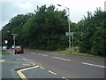
Coldean Wood
From Coldean Lane, opposite the Hikers Rest
Image: © Paul Gillett
Taken: 15 Jul 2009
0.12 miles
5
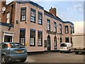
Hikers Rest, Coldean
details & reviews: http://www.viewbrighton.co.uk/pubsandbars/hikers-rest-info-58912.html
Image: © Paul Gillett
Taken: 15 Apr 2012
0.14 miles
6
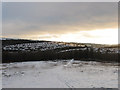
View from Marquee Brow
Looking down the southern slope of the hill that has been sliced in two by the construction of the Brighton By-pass leaving this rather forlorn corner of Stanmer Park separated from the rest. The woods at the bottom are Coldean Belt to the left and Coldean Wood to the right. Moulescoomb is the suburb on the left, a council estate built in the 1930s whilst the valley containing the Lewes Road heads off to the right towards the centre of the city.
Image: © Simon Carey
Taken: 18 Dec 2010
0.14 miles
7
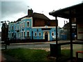
Hikers Rest, Coldean
Situated at the junction of the A270 Lewes Road and the bottom of Coldean Lane, details: http://www.beerintheevening.com/pubs/s/47/4735/Hikers_Rest/Brighton
Image: © Paul Gillett
Taken: 15 Jul 2009
0.15 miles
8
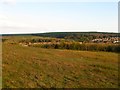
Stanmer Hill Fifteen Acres
The name of the field according to Falmer's 1840 tithe map that is part of Stanmer Park that was detached when the A27 bypass was constructed in the early 1990s. The land is open access but seems to have been left with no idea what to do with it. Coldean Belt is the wood in the distance with the suburb of Moulescoomb beyond.
Image: © Simon Carey
Taken: 19 Apr 2014
0.15 miles