IMAGES TAKEN NEAR TO
Framfield Close, BRIGHTON, BN1 9GT
Introduction
This page details the photographs taken nearby to Framfield Close, BN1 9GT by members of the Geograph project.
The Geograph project started in 2005 with the aim of publishing, organising and preserving representative images for every square kilometre of Great Britain, Ireland and the Isle of Man.

There are currently over 7.5m images from over14,400 individuals and you can help contribute to the project by visiting https://www.geograph.org.uk
Image Map
Images are licensed for reuse under creativecommons.org/licenses/by-sa/2.0
Notes
- Clicking on the map will re-center to the selected point.
- The higher the marker number, the further away the image location is from the centre of the postcode.
Image Listing (29 Images Found)
Images are licensed for reuse under creativecommons.org/licenses/by-sa/2.0
Image
Details
Distance
1
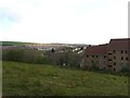
Plantation Piece (2)
The name of the field according to Stanmer's 1840 tithe map. This is the eastern part of the former much of which has been lost to Varley Park to the right and construction of the A27 bypass during the 1990s out of shot to the left. In the distance is the suburb of Moulescoomb and Race Hill. See also Image
Image: © Simon Carey
Taken: 19 Apr 2014
0.05 miles
3
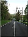
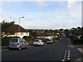
Coldean Lane, Coldean
The only access route to the suburb of Coldean is an ancient lane that connects Lewes Road to Image At this point the road begins a steep climb up Chalk Hill towards the latter.
Image: © Simon Carey
Taken: 19 Apr 2014
0.12 miles
4
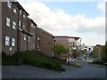
Varley Park, University of Brighton
The original set of halls were built during the 1970s and were added to during the 1990s. In the last five years there has been a further expansion of blocks.
Image: © Simon Carey
Taken: 19 Apr 2014
0.14 miles
5
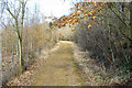
Path, Great Wood, Stanmer Park
Between two bridges over the A27.
Image: © Robin Webster
Taken: 2 Mar 2010
0.15 miles
6
Rushlake Road, Coldean
Linking Hawkhurst Road to Park Road and running parallel to Coldean Lane. It was originally known as West Drive but changed sometime in the 1960s.
Image: © Simon Carey
Taken: 23 Sep 2011
0.16 miles
7
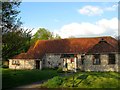
St Mary Magdalen, Coldean
The local church is in fact a converted flint barn that once belonged to Coldean Farm that was later known as The Menagerie that was demolished to make way for Image The barn dates back to 1780 and for many centuries was the only building 0n the western side of Coldean Lane. It was converted to its current use in 1955.
Image: © Simon Carey
Taken: 19 Apr 2014
0.17 miles
8
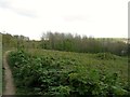
Plantation Piece (1)
The name of the field according to Stanmer's 1840 tithe map that is now little more than rough ground. This is the northern section of the old field part of which was lost to the building of the A27 bypass during the early 1990s and gradual extension of Image to the south. Beyond the small wood in the distance is another section of the former field, see Image
Image: © Simon Carey
Taken: 19 Apr 2014
0.18 miles
9
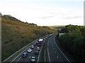
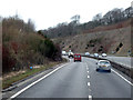
Brighton By-Pass
Looking down the A27 from the footbridge that carries the footpath that links Great Wood to Coldean. A mixture of rush hour traffic and vehicles heading towards Brighton & Hove Albion's Amex Stadium is causing the build up on the eastbound carriageway.
Image: © Simon Carey
Taken: 21 Sep 2011
0.18 miles
10
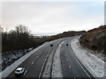
Brighton By-Pass
Built in the 1990s to take the A27 away from the congested city centre. This section begins its climb up Chalk Hill cutting through a corner of Stanmer Park in the process.
Image: © Simon Carey
Taken: 18 Dec 2010
0.19 miles