IMAGES TAKEN NEAR TO
Church Hill, BRIGHTON, BN1 8YU
Introduction
This page details the photographs taken nearby to Church Hill, BN1 8YU by members of the Geograph project.
The Geograph project started in 2005 with the aim of publishing, organising and preserving representative images for every square kilometre of Great Britain, Ireland and the Isle of Man.

There are currently over 7.5m images from over14,400 individuals and you can help contribute to the project by visiting https://www.geograph.org.uk
Image Map
Images are licensed for reuse under creativecommons.org/licenses/by-sa/2.0
Notes
- Clicking on the map will re-center to the selected point.
- The higher the marker number, the further away the image location is from the centre of the postcode.
Image Listing (134 Images Found)
Images are licensed for reuse under creativecommons.org/licenses/by-sa/2.0
Image
Details
Distance
1
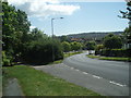
Vale Avenue, Patcham
Near to the A27 Brighton Bypass
Image: © Paul Gillett
Taken: 22 May 2009
0.02 miles
4
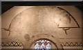
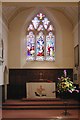
All Saints, Patcham, Sussex - Chancel arch
Image: © John Salmon
Taken: 4 Sep 2003
0.02 miles
6
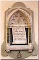
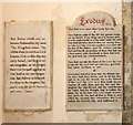
All Saints, Patcham, Sussex - Wall monument
Image: © John Salmon
Taken: 4 Sep 2003
0.03 miles
8
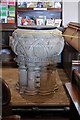
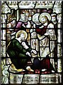
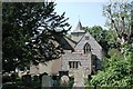
All Saints Church, Patcham
Parts of the church date from the 12th and 13th centuries. There were additions during the 19th century. This is when a 13th century painting above the chancel arch was discovered.
Image: © Peter Holmes
Taken: 6 Oct 2007
0.03 miles
10
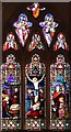
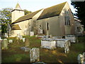
All Saints, Patcham, Sussex - East window
Image: © John Salmon
Taken: 4 Sep 2003
0.03 miles