IMAGES TAKEN NEAR TO
Graham Avenue, BRIGHTON, BN1 8HD
Introduction
This page details the photographs taken nearby to Graham Avenue, BN1 8HD by members of the Geograph project.
The Geograph project started in 2005 with the aim of publishing, organising and preserving representative images for every square kilometre of Great Britain, Ireland and the Isle of Man.

There are currently over 7.5m images from over14,400 individuals and you can help contribute to the project by visiting https://www.geograph.org.uk
Image Map
Images are licensed for reuse under creativecommons.org/licenses/by-sa/2.0
Notes
- Clicking on the map will re-center to the selected point.
- The higher the marker number, the further away the image location is from the centre of the postcode.
Image Listing (7 Images Found)
Images are licensed for reuse under creativecommons.org/licenses/by-sa/2.0
Image
Details
Distance
2
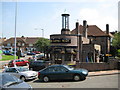
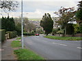
Patcham: The Long Man public house
Named after Image and located in Wilmington Way the pub is contemporary with the 1930s housing development of Patcham, but what is the function of the glass tower with the pinnacle roof?
Image: © Nigel Cox
Taken: 8 Jun 2008
0.12 miles
3
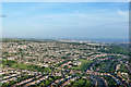
Aerial view over Patcham and Hollingbury
And also further over the eastern part of Brighton.
Image: © Robin Webster
Taken: 27 Jun 2015
0.15 miles
5
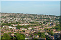
Patcham and Hollingbury from the air
A view over the northern suburbs of Brighton from a hot-air balloon.
Image: © Robin Webster
Taken: 27 Jun 2015
0.20 miles