IMAGES TAKEN NEAR TO
Cuckmere Way, BRIGHTON, BN1 8GF
Introduction
This page details the photographs taken nearby to Cuckmere Way, BN1 8GF by members of the Geograph project.
The Geograph project started in 2005 with the aim of publishing, organising and preserving representative images for every square kilometre of Great Britain, Ireland and the Isle of Man.

There are currently over 7.5m images from over14,400 individuals and you can help contribute to the project by visiting https://www.geograph.org.uk
Image Map
Images are licensed for reuse under creativecommons.org/licenses/by-sa/2.0
Notes
- Clicking on the map will re-center to the selected point.
- The higher the marker number, the further away the image location is from the centre of the postcode.
Image Listing (28 Images Found)
Images are licensed for reuse under creativecommons.org/licenses/by-sa/2.0
Image
Details
Distance
1
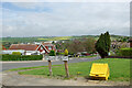
Cuckmere Way, Hollingbury, Brighton
This suburban area has a great many Crescents, but the more major roads tend not to be.
Image: © Robin Webster
Taken: 30 Apr 2010
0.03 miles
2
Ditchling Crescent, Hollingbury, Brighton
Image: © Robin Webster
Taken: 30 Apr 2010
0.05 miles
3
Ditchling Crescent, Hollingbury, Brighton
Image: © Robin Webster
Taken: 30 Apr 2010
0.07 miles
4
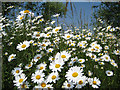
Daisies at Hollingbury Wild Park Nature Reserve
Typical plants of chalk grassland, these ox-eye daisies (Leucanthemum vulgare) were flowering in abundance in the car park.
Image: © Cathy Cox
Taken: 8 Jun 2008
0.09 miles
5
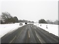
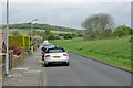
Ditchling Road
One of the longest and highest roads in the Brighton & Hove area stretching from St Peter's Church to Ditchling Beacon. The road was turnpiked in 1770 and for a while was part of the main London-Brighton route. Behind the trees to the left is a small car park for those wishing to walk the fields beyond which are now all open access or have a number of permissive footpaths crisscrossing them. A car has indeed gone in to park there whilst these two have decided not to risk it on this day of heavy snow though the road itself is mercifully ice free if a little slushy.
Image: © Simon Carey
Taken: 20 Jan 2013
0.09 miles
6
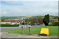
View from end of Ditchling Crescent
One of the higher points of the northern Brighton suburbs.
Image: © Robin Webster
Taken: 30 Apr 2010
0.09 miles

8
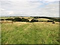
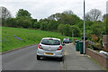
Path from Brighton Wild Park to Ditchling Road
Path over grassland on the Downs with a view north towards Ditchling Beacon in the distance.
Image: © Patrick Roper
Taken: 22 Aug 2009
0.10 miles
9
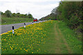
Bluebell time, Ditchling Road
Bluebell time is also Dandelion time.
Image: © Robin Webster
Taken: 30 Apr 2010
0.10 miles
10
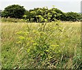
Wild parsnip in Brighton Wild Park
Wild parsnip (Pastinaca sativa) is widespread and common in grassland on the South Downs and elsewhere in Britain.
Image: © Patrick Roper
Taken: 6 Aug 2009
0.11 miles