IMAGES TAKEN NEAR TO
Fernhurst Close, BRIGHTON, BN1 8FE
Introduction
This page details the photographs taken nearby to Fernhurst Close, BN1 8FE by members of the Geograph project.
The Geograph project started in 2005 with the aim of publishing, organising and preserving representative images for every square kilometre of Great Britain, Ireland and the Isle of Man.

There are currently over 7.5m images from over14,400 individuals and you can help contribute to the project by visiting https://www.geograph.org.uk
Image Map
Images are licensed for reuse under creativecommons.org/licenses/by-sa/2.0
Notes
- Clicking on the map will re-center to the selected point.
- The higher the marker number, the further away the image location is from the centre of the postcode.
Image Listing (25 Images Found)
Images are licensed for reuse under creativecommons.org/licenses/by-sa/2.0
Image
Details
Distance
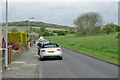
1
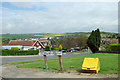
View from end of Ditchling Crescent
One of the higher points of the northern Brighton suburbs.
Image: © Robin Webster
Taken: 30 Apr 2010
0.05 miles
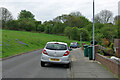
2
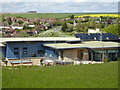
Carden Hill Medical Centre
Built in 2008.
Image: © Brian Slater
Taken: 25 Apr 2009
0.08 miles
3
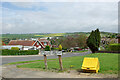
Cuckmere Way, Hollingbury, Brighton
This suburban area has a great many Crescents, but the more major roads tend not to be.
Image: © Robin Webster
Taken: 30 Apr 2010
0.14 miles
5
Ditchling Crescent, Hollingbury, Brighton
Image: © Robin Webster
Taken: 30 Apr 2010
0.16 miles
6
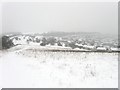
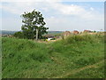
Open Access Land, Hollingbury
A large swathe of downland between Ditchling Road and the built up estates of Hollingbury are now open access. The large amount of snow falling is reducing visibility somewhat.
Image: © Simon Carey
Taken: 20 Jan 2013
0.17 miles
8
Ditchling Crescent, Hollingbury, Brighton
Image: © Robin Webster
Taken: 30 Apr 2010
0.19 miles
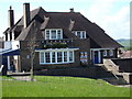
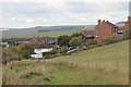
9

Carden Avenue, Hollingbury
The main thoroughfare for the estates that were built to the east of Patcham between the 1930s and 1950s beginning at London Road, the A23 in the west and ending at Ditchling Road at Old Boat corner in the east. This view looks down the hill towards Carden Primary School.
Image: © Simon Carey
Taken: 20 Jan 2013
0.20 miles
10
Short footpath linking Ditchling Road with housing Elsted Crescent
Image: © Dave Spicer
Taken: 12 Aug 2012
0.20 miles