
IMAGES TAKEN NEAR TO
Saddlescombe Road, BN1 8AX
Introduction
This page details the photographs taken nearby to Saddlescombe Road, BN1 8AX by members of the Geograph project.
The Geograph project started in 2005 with the aim of publishing, organising and preserving representative images for every square kilometre of Great Britain, Ireland and the Isle of Man.

There are currently over 7.5m images from over14,400 individuals and you can help contribute to the project by visiting https://www.geograph.org.uk
Image Map
Images are licensed for reuse under creativecommons.org/licenses/by-sa/2.0
Notes
- Clicking on the map will re-center to the selected point.
- The higher the marker number, the further away the image location is from the centre of the postcode.
Image Listing (10 Images Found)
Images are licensed for reuse under creativecommons.org/licenses/by-sa/2.0
Image
Details
Distance
1
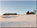
Clubhouse, Waterhall Golf Course
Viewed from the footpath that links Waterhall playing fields with Sweet Hill.
Image: © Simon Carey
Taken: 20 Dec 2009
0.01 miles
2
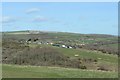
Waterhall Clubhouse
Waterhall Golf Course viewed from the Dyke Road car park.
Image: © Peter Jeffery
Taken: 12 Feb 2020
0.03 miles
3
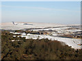
Clubhouse, Waterhall Golf Course
Viewed from the car park off Saddlescombe Road on Red Hill and looking across the western end of Waterhall to the clubhouse that sits perched on a hill top. A 9 hole golf course was laid out in 1922 and expanded to 18 holes in 1934 taking over the grounds of a nudist camp in the process. The course came under the ownership of the council in 1936 and remains so today. Varncombe Hill is beyond the course.
Image: © Simon Carey
Taken: 4 Feb 2009
0.04 miles
4
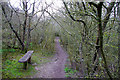
A seat in the thicket
In Waterhall local nature reserve. The bushes here have an amazing lichen growth for such young scrub.
Image: © Robin Webster
Taken: 7 Apr 2010
0.11 miles
5
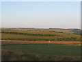
Practice ground at Waterhall golf course
The Ditchling Beacon road follows the tree line on the horizon.
Image: © Dave Spicer
Taken: 18 Jul 2013
0.12 miles
6
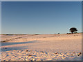
Eighteenth Hole, Waterhall Golf Course
Municipal owned golf course that lies amongst the Downs to the north of the by-pass and east of Devil's Dyke Road. The layer of snow gets added colour from the early morning sun.
Image: © Simon Carey
Taken: 20 Dec 2009
0.14 miles
7
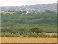
Downland North of Brighton
View from Devil's Dyke Road towards Patcham Windmill. Cereal crop in the foreground - many fields on the chalky South Downs carry barley / wheat. Amongst the woodland are street lights following the A27 alignment. In the distance are northern suburbs of Brighton.
Image: © Colin Smith
Taken: 31 Jul 2010
0.16 miles
8
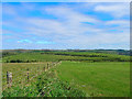
Waterhall Golf Course
Taken from the edge of the square looking north east with Sweet Hill in the background marking the eastern boundary of the square.
Image: © Simon Carey
Taken: 18 Sep 2005
0.17 miles
9
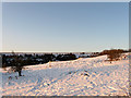
Second Hole, Waterhall Golf Course
Municipal owned golf course that lies amongst the Downs to the north of the by-pass and east of Devil's Dyke Road. Looking towards the second hole from the footpath that comes up from Waterhall below with Red Hill in the distance. All carpeted with snow that was deposited 48 hours ago.
Image: © Simon Carey
Taken: 20 Dec 2009
0.20 miles
10
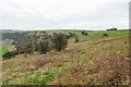
CRoW access downland
The access land is the crescent of grass and scrub between the golf course below on the left and improved grassland beside Saddlescombe Road along the hill crest.
Image: © Robin Webster
Taken: 7 Apr 2010
0.20 miles