IMAGES TAKEN NEAR TO
Carden Hill, BRIGHTON, BN1 8AB
Introduction
This page details the photographs taken nearby to Carden Hill, BN1 8AB by members of the Geograph project.
The Geograph project started in 2005 with the aim of publishing, organising and preserving representative images for every square kilometre of Great Britain, Ireland and the Isle of Man.

There are currently over 7.5m images from over14,400 individuals and you can help contribute to the project by visiting https://www.geograph.org.uk
Image Map
Images are licensed for reuse under creativecommons.org/licenses/by-sa/2.0
Notes
- Clicking on the map will re-center to the selected point.
- The higher the marker number, the further away the image location is from the centre of the postcode.
Image Listing (13 Images Found)
Images are licensed for reuse under creativecommons.org/licenses/by-sa/2.0
Image
Details
Distance
1
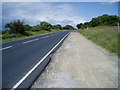
Lay-by on Ditchling Road
With finger post indicating public footpath to Hollingbury Hill Fort.
Image: © Peter Holmes
Taken: 9 Jun 2011
0.07 miles
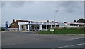
3
Woodbourne Garage on Cuckmere Way Hollingbury
Hollingbury is one of the northerly suburbs of Brighton.
Image: © Dave Spicer
Taken: 12 Aug 2012
0.11 miles
4
Woodbourne Garage
On the Ditchling Road opposite Hollingbury Golf Course
Image: © Paul Gillett
Taken: 19 Sep 2010
0.14 miles
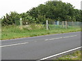
5
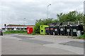
Recycling bins, Hollingbury
By a useful little car park just off Ditchling Road.
Image: © Robin Webster
Taken: 30 Apr 2010
0.15 miles
6

Route to Hill Fort
Post indicating route of public footpath across golf course.
Image: © Peter Holmes
Taken: 9 Jun 2011
0.17 miles
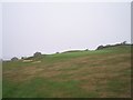
7
Footpath, Hollingbury Park Golf Course
Where it exactly goes is anybody's guess, I just followed the straight line indicated by the arrow. The footpath links Ditchling Road to Hollingbury Castle.
Image: © Simon Carey
Taken: 20 Jan 2013
0.20 miles
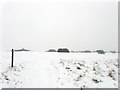
8
Hollingbury Park Golf Course
First laid out in 1908 as a nine hole course it was extended to 18 in 1910 and completely remodelled in 1936. The course is still council owned and sits high on Hollingbury Hill with views down to the coast and northwards into the Downs. Not much golf was going on on this day but the open space was being utilised by many others enjoying the snow.
Image: © Simon Carey
Taken: 20 Jan 2013
0.21 miles
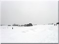
9
Golf Course near Hollingbury Hill Fort
Looking North West from a most dangerous footpath. Just after taking this a golf ball landed at my feet.
Image: © Bob Embleton
Taken: 11 Sep 2005
0.23 miles
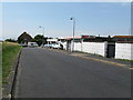
10
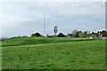
Reservoir, Hollingbury
Covered reservoirs, the bank on the left has uncommon plants.
Image: © Robin Webster
Taken: 30 Apr 2010
0.23 miles