IMAGES TAKEN NEAR TO
Burpham, ARUNDEL, BN18 9RJ
Introduction
This page details the photographs taken nearby to BN18 9RJ by members of the Geograph project.
The Geograph project started in 2005 with the aim of publishing, organising and preserving representative images for every square kilometre of Great Britain, Ireland and the Isle of Man.

There are currently over 7.5m images from over14,400 individuals and you can help contribute to the project by visiting https://www.geograph.org.uk
Image Map
Images are licensed for reuse under creativecommons.org/licenses/by-sa/2.0
Notes
- Clicking on the map will re-center to the selected point.
- The higher the marker number, the further away the image location is from the centre of the postcode.
Image Listing (203 Images Found)
Images are licensed for reuse under creativecommons.org/licenses/by-sa/2.0
Image
Details
Distance
1
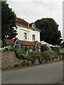
Burpham Country House Hotel
The four star hotel is located on The Street and has seen a variety of different uses since constructed in 1710. It started life as a hunting lodge, later became the village poorhouse then in 1845 was turned into the village rectory and extensively remodelled until its sale in 1936 whereupon it was transformed into a country hotel which it remains today. A blue plaque on the wall commemorates the building as the former home of naturalist and author Tickner Edwardes whose novel tansy was made into a film in 1921 and shot mostly in the village using locals as extras. He is buried in St Mary's church, see Image
Image: © Simon Carey
Taken: 14 Aug 2013
0.00 miles
2
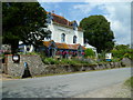
Guest House and restaurant at Burpham
The blue plaque commemorates Tickner Edwardes who lived here when he was the vicar of Burpham.
Image: © Shazz
Taken: 3 Jul 2011
0.01 miles
3
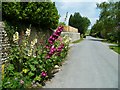
Hollyhocks in Burpham
This is the main street which seems not to have a name.
Image: © Shazz
Taken: 3 Jul 2011
0.01 miles
4
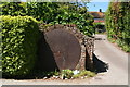
Rimming plate house sign
A rimming plate was used for building wooden cart or carriage wheels. The wheel hub was placed in the centre, and the spokes and wooden wheel rim fitted onto it over the rimming plate. The iron tyre (outer rim) was heated over a fire to expand it, then carried over put onto the outside of the wooden rim. It was then quenched with water to shrink it so for a tight fit.
For another rimming plate see: Image
Image: © Chris
Taken: 14 Jun 2013
0.02 miles
5
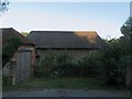
88-89, The Street, Burpham
A pair of cottages that lie at right angles to the village street that have retained their old estate numbers. The flint cottages dates from the 18th century.
Image: © Simon Carey
Taken: 14 Aug 2013
0.03 miles
6
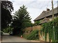
Thatched Barn, The Street, Burpham
Once part of the outbuildings belonging to Image the barn dates from the 18th century and does not seem to have been converted.
Image: © Simon Carey
Taken: 3 Aug 2013
0.04 miles
7
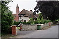
Burpham
I was a little puzzled; the foreground wall relates to a new property which lies out of picture, but the flint wall and brick chimney of the next house look similarly new. However, the tiled roof looks older.
Image: © Peter Trimming
Taken: 9 Jun 2018
0.04 miles
8

Turkey Plat
The name of the field according to Burpham's 1840 tithe map viewed from the footpath that links St Mary's church to Peppering Lane. Perry Hill lies beyond.
Image: © Simon Carey
Taken: 3 Aug 2013
0.05 miles
9

Green Garden
The name of the field according to Burpham's 1840 tithe map that has been expanded to include Image to the east. Perry Hill provides the backdrop whilst beyond the foliage at the end of the field are the rear gardens of the houses in Burpham's main village street.
Image: © Simon Carey
Taken: 3 Aug 2013
0.05 miles
10
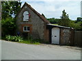
Dwelling in Burpham
This is a converted stables with an old blue pump by the road.
Image: © Shazz
Taken: 3 Jul 2011
0.05 miles